
Graham Island topographic map
Interactive map
Click on the map to display elevation.
About this map
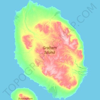
Name: Graham Island topographic map, elevation, terrain.
Location: Graham Island, Qikiqtaaluk Region, Nunavut, Canada (77.19650 -91.23375 77.66085 -89.63100)
Average elevation: 29 m
Minimum elevation: -1 m
Maximum elevation: 184 m
Other topographic maps
Click on a map to view its topography, its elevation and its terrain.
Round Island
Canada > Nunavut > Qikiqtaaluk Region
Round Island, Qikiqtaaluk Region, Nunavut, Canada
Average elevation: 78 m
Sentinel Island
Canada > Nunavut > Qikiqtaaluk Region
Sentinel Island, Qikiqtaaluk Region, Nunavut, Canada
Average elevation: 5 m