
Mojokerto topographic map
Interactive map
Click on the map to display elevation.
About this map
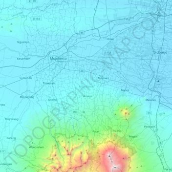
Name: Mojokerto topographic map, elevation, terrain.
Location: Mojokerto, Jawa Timur, Indonésie (-7.77913 112.33276 -7.30311 112.67082)
Average elevation: 280 m
Minimum elevation: -2 m
Maximum elevation: 3,307 m
Other topographic maps
Click on a map to view its topography, its elevation and its terrain.
Bajulan
Indonésie > Jawa Timur > Madiun
Bajulan, Madiun, Jawa Timur, 63153, Indonésie
Average elevation: 76 m
Pasuruan
Indonésie > Jawa Timur > Pasuruan
Pasuruan, Jawa Timur, 67114, Indonésie
Average elevation: 44 m