
Malang topographic map
Interactive map
Click on the map to display elevation.
About this map
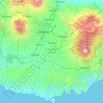
Name: Malang topographic map, elevation, terrain.
Location: Malang, Jawa Timur, Indonésie (-8.46393 112.28741 -7.76111 112.95767)
Average elevation: 657 m
Minimum elevation: 0 m
Maximum elevation: 3,648 m
Other topographic maps
Click on a map to view its topography, its elevation and its terrain.
Bajulan
Indonésie > Jawa Timur > Madiun
Bajulan, Madiun, Jawa Timur, 63153, Indonésie
Average elevation: 76 m
Pasuruan
Indonésie > Jawa Timur > Pasuruan
Pasuruan, Jawa Timur, 67114, Indonésie
Average elevation: 44 m