
Thank you for supporting this site ❤️
Make a donation
Make a donation
Mangystau Region topographic map
Click on the map to display elevation.
Thank you for supporting this site ❤️
Make a donation
Make a donation
About this map
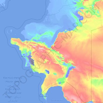
Name: Mangystau Region topographic map, elevation, terrain.
Location: Mangystau Region, Kazakhstan (41.24639 49.80829 46.52013 56.74411)
Average elevation: 56 m
Minimum elevation: -130 m
Maximum elevation: 487 m
Thank you for supporting this site ❤️
Make a donation
Make a donation
Other topographic maps
Click on a map to view its topography, its elevation and its terrain.
Qulsarı
Kazakhstan > Atyrau Region > Zhylyoi District > Құлсары қалалық әкімдігі
Average elevation: -11 m
Bulaq
Kazakhstan > North Kazakhstan Region > Esil District > Булакский сельский округ
Average elevation: 180 m
Border Kazakhstan - Russia
Kazakhstan > East Kazakhstan Region > Katonkaragay District
Average elevation: 2,676 m
Thank you for supporting this site ❤️
Make a donation
Make a donation