
Make a donation
Harare topographic map
Click on the map to display elevation.
Make a donation
Harare
Harare (/həˈrɑːreɪ/ hə-RAR-ay), formerly known as Salisbury (/ˈsɔːlzbəri/ SAWLZ-bər-ee), is the capital and largest city of Zimbabwe, and is the most populous city in the country. The city proper has an area of 982.3km2 (378.7 mi2), a population of 1,849,600 as of the 2022 census and an estimated 2,487,209 people in its metropolitan province. The city is situated in north-eastern Zimbabwe in the country's Mashonaland region. Harare is a metropolitan province, which also incorporates the municipalities of Chitungwiza and Epworth. The city sits on a plateau at an elevation of 1,483 metres (4,865 feet) above sea level, and its climate falls into the subtropical highland category.
Make a donation
About this map
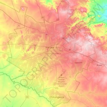
Name: Harare topographic map, elevation, terrain.
Location: Harare, Zimbabwe (-18.05099 30.87743 -17.65716 31.22145)
Average elevation: 1,461 m
Minimum elevation: 1,281 m
Maximum elevation: 1,603 m
Make a donation
Other topographic maps
Click on a map to view its topography, its elevation and its terrain.
Batoka Gorge
Zimbabwe > Matabeleland North Province > Hwange > Victoria Falls
Average elevation: 861 m
Make a donation
Bulawayo
Zimbabwe > Bulawayo Province > Bulawayo
Due to its relatively high altitude, the city has a humid subtropical climate despite lying in the tropics. Under the Köppen climate classification, Bulawayo features a semiarid climate (BSh). The mean annual temperature is 19.16 °C (66.49 °F), similar to Pretoria at a similar altitude but almost 600 km…
Average elevation: 1,348 m
Kariba
Zimbabwe > Mashonaland West > Kariba > Kariba
Kariba has a tropical savanna climate (Köppen climate classification Aw), with warm winters and very hot summers, and a marked drier season in the winter. Although it is relatively cooler than typical tropical places in the winter and does get occasional 5 °C (41 °F) lows, Kariba nevertheless meets the…
Average elevation: 550 m
Hwange
Zimbabwe > Matabeleland North Province > Hwange
Hwange, originally known as Wankie, is a town in Zimbabwe, located in Hwange District, in Matabeleland North Province, in northwestern Zimbabwe, close to the international borders with Botswana and Zambia. It lies approximately 100 kilometres (62 mi), by road, southeast of Victoria Falls, the nearest large…
Average elevation: 774 m
Make a donation