
Pike County topographic map
Interactive map
Click on the map to display elevation.
About this map
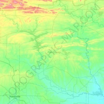
Name: Pike County topographic map, elevation, terrain.
Location: Pike County, Arkansas, United States (33.94367 -93.93708 34.35019 -93.36721)
Average elevation: 171 m
Minimum elevation: 62 m
Maximum elevation: 588 m
Other topographic maps
Click on a map to view its topography, its elevation and its terrain.
Austin
United States > Arkansas > Lonoke County > Austin
Austin, Lonoke County, Arkansas, United States
Average elevation: 83 m
Fort Smith
United States > Arkansas > Sebastian County > Fort Smith
Fort Smith, Sebastian County, Arkansas, United States
Average elevation: 140 m
Little Rock
United States > Arkansas > Pulaski County > Little Rock
Little Rock, Pulaski County, Arkansas, 72201-1822, United States
Average elevation: 98 m
Fayetteville
United States > Arkansas > Washington County
Fayetteville, Washington County, Arkansas, United States
Average elevation: 401 m