
Fayetteville topographic map
Interactive map
Click on the map to display elevation.
About this map
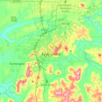
Name: Fayetteville topographic map, elevation, terrain.
Location: Fayetteville, Washington County, Arkansas, United States (35.98936 -94.29778 36.14893 -94.02671)
Average elevation: 401 m
Minimum elevation: 325 m
Maximum elevation: 581 m
Fayetteville has a humid subtropical climate (Köppen Cfa). Fayetteville experiences all four seasons and does receive cold air masses from the north; however, some of the Arctic masses are blocked by the higher elevations of the Ozarks.