
Thank you for supporting this site ❤️
Make a donation
Make a donation
Koper / Capodistria topographic map
Click on the map to display elevation.
Thank you for supporting this site ❤️
Make a donation
Make a donation
About this map
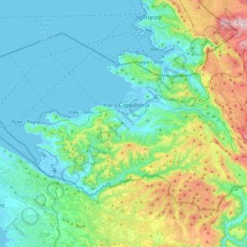
Name: Koper / Capodistria topographic map, elevation, terrain.
Average elevation: 152 m
Minimum elevation: -3 m
Maximum elevation: 727 m
Thank you for supporting this site ❤️
Make a donation
Make a donation
Other topographic maps
Click on a map to view its topography, its elevation and its terrain.
Thank you for supporting this site ❤️
Make a donation
Make a donation
Ljubljana
Ljubljana has an elevation of 295 meters (968 ft) The city centre, located along the Ljubljanica River, has an elevation of 298 meters (978 ft). Ljubljana Castle, which sits atop Castle Hill (Grajski grič) south of the city centre, has an elevation of 366 meters (1,201 ft). The highest point of the city,…
Average elevation: 412 m
Thank you for supporting this site ❤️
Make a donation
Make a donation