
Thank you for supporting this site ❤️
Make a donation
Make a donation
Lokve topographic map
Click on the map to display elevation.
Thank you for supporting this site ❤️
Make a donation
Make a donation
About this map
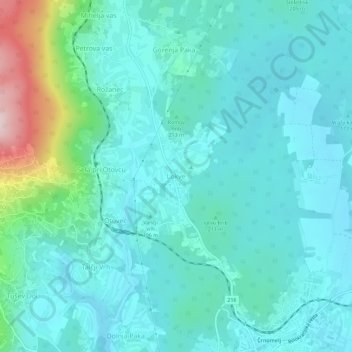
Name: Lokve topographic map, elevation, terrain.
Location: Lokve, Črnomelj, 8340, Slovenia (45.57753 15.15474 45.61753 15.19474)
Average elevation: 209 m
Minimum elevation: 147 m
Maximum elevation: 506 m
Thank you for supporting this site ❤️
Make a donation
Make a donation