
Thank you for supporting this site ❤️
Make a donation
Make a donation
Hokah topographic map
Click on the map to display elevation.
Thank you for supporting this site ❤️
Make a donation
Make a donation
About this map
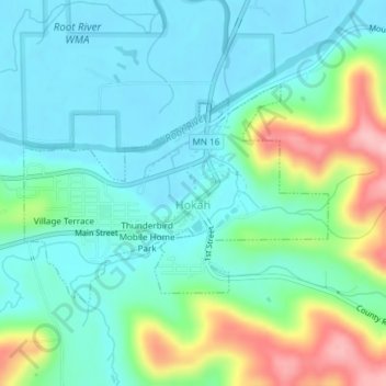
Name: Hokah topographic map, elevation, terrain.
Location: Hokah, Houston County, Minnesota, United States (43.75262 -91.36294 43.76789 -91.33341)
Average elevation: 235 m
Minimum elevation: 194 m
Maximum elevation: 351 m
Thank you for supporting this site ❤️
Make a donation
Make a donation
Other topographic maps
Click on a map to view its topography, its elevation and its terrain.
Thank you for supporting this site ❤️
Make a donation
Make a donation
Thank you for supporting this site ❤️
Make a donation
Make a donation
Thank you for supporting this site ❤️
Make a donation
Make a donation