
Gouvy topographic map
Interactive map
Click on the map to display elevation.
About this map
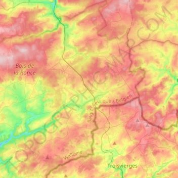
Name: Gouvy topographic map, elevation, terrain.
Location: Gouvy, Bastogne, Luxembourg, Wallonia, Belgium (50.11023 5.78809 50.27034 6.03439)
Average elevation: 483 m
Minimum elevation: 354 m
Maximum elevation: 599 m
Other topographic maps
Click on a map to view its topography, its elevation and its terrain.
Ourthe
Belgium > Luxembourg > Bastogne
Ourthe, Gouvy, Bastogne, Luxembourg, Wallonia, 6672, Belgium
Average elevation: 491 m
Ollomont
Belgium > Luxembourg > Bastogne > Houffalize
Ollomont, Nadrin, Houffalize, Bastogne, Luxembourg, Wallonia, 6982, Belgium
Average elevation: 376 m
Wibrin
Belgium > Luxembourg > Bastogne
Wibrin, Houffalize, Bastogne, Luxembourg, Wallonia, Belgium
Average elevation: 424 m
Bastogne
Belgium > Luxembourg > Bastogne
Bastogne, Luxembourg, Wallonia, 6600, Belgium
Average elevation: 465 m
Regné
Belgium > Luxembourg > Bastogne
Regné, Vielsalm, Bastogne, Luxembourg, Wallonia, 4990, Belgium
Average elevation: 536 m
Rogery
Belgium > Luxembourg > Bastogne > Rogery
Rogery, Gouvy, Bastogne, Luxembourg, Wallonia, 6671, Belgium
Average elevation: 485 m
Gouvy
Belgium > Luxembourg > Bastogne > Gouvy
Gouvy, Bastogne, Luxembourg, Wallonia, Belgium
Average elevation: 469 m
Houffalize
Belgium > Luxembourg > Bastogne
Houffalize, Bastogne, Luxembourg, Wallonia, Belgium
Average elevation: 463 m
Vielsalm
Belgium > Luxembourg > Bastogne
Vielsalm, Bastogne, Luxembourg, Wallonia, Belgium
Average elevation: 472 m
Baclain
Belgium > Luxembourg > Bastogne
Baclain, Gouvy, Bastogne, Luxembourg, Wallonia, 6673, Belgium
Average elevation: 469 m