
Ourthe topographic map
Interactive map
Click on the map to display elevation.
About this map
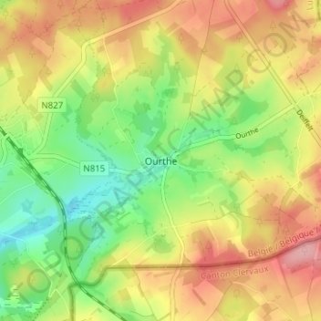
Name: Ourthe topographic map, elevation, terrain.
Location: Ourthe, Gouvy, Bastogne, Luxembourg, Wallonia, 6672, Belgium (50.16838 5.96147 50.20838 6.00147)
Average elevation: 491 m
Minimum elevation: 429 m
Maximum elevation: 556 m
Other topographic maps
Click on a map to view its topography, its elevation and its terrain.
Ollomont
Belgium > Luxembourg > Bastogne > Houffalize
Ollomont, Nadrin, Houffalize, Bastogne, Luxembourg, Wallonia, 6982, Belgium
Average elevation: 376 m
Wibrin
Belgium > Luxembourg > Bastogne
Wibrin, Houffalize, Bastogne, Luxembourg, Wallonia, Belgium
Average elevation: 424 m
Bastogne
Belgium > Luxembourg > Bastogne
Bastogne, Luxembourg, Wallonia, 6600, Belgium
Average elevation: 465 m
Regné
Belgium > Luxembourg > Bastogne
Regné, Vielsalm, Bastogne, Luxembourg, Wallonia, 4990, Belgium
Average elevation: 536 m
Rogery
Belgium > Luxembourg > Bastogne > Rogery
Rogery, Gouvy, Bastogne, Luxembourg, Wallonia, 6671, Belgium
Average elevation: 485 m
Gouvy
Belgium > Luxembourg > Bastogne > Gouvy
Gouvy, Bastogne, Luxembourg, Wallonia, Belgium
Average elevation: 469 m
Houffalize
Belgium > Luxembourg > Bastogne
Houffalize, Bastogne, Luxembourg, Wallonia, Belgium
Average elevation: 463 m
Vielsalm
Belgium > Luxembourg > Bastogne
Vielsalm, Bastogne, Luxembourg, Wallonia, Belgium
Average elevation: 472 m
Gouvy
Belgium > Luxembourg > Bastogne
Gouvy, Bastogne, Luxembourg, Wallonia, Belgium
Average elevation: 483 m
Baclain
Belgium > Luxembourg > Bastogne
Baclain, Gouvy, Bastogne, Luxembourg, Wallonia, 6673, Belgium
Average elevation: 469 m