
Make a donation
Tai Po District topographic map
Click on the map to display elevation.
Make a donation
About this map
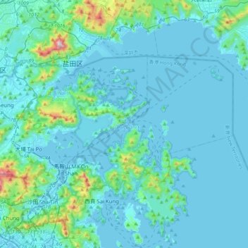
Name: Tai Po District topographic map, elevation, terrain.
Location: Tai Po District, New Territories, Hong Kong, China (22.39360 114.11194 22.56813 114.45602)
Average elevation: 79 m
Minimum elevation: -4 m
Maximum elevation: 905 m
Make a donation
Other topographic maps
Click on a map to view its topography, its elevation and its terrain.
River Ganges (Ping Yuen River)
China > Hong Kong > North District > Ping Che > Ping Che Yuen Ha
Average elevation: 23 m
Lantau Peak
China > Hong Kong > Islands District
Lantau Peak is located in central Lantau Island, with an elevation of 934 meters above sea level (23 metres shorter than Tai Mo Shan, Hong Kong's highest peak). Under the Köppen climate classification, Lantau Peak features a subtropical highland climate. Due to its elevation, strong winds and fog occur…
Average elevation: 422 m
Tsing Tam Lower Reservoir
China > Hong Kong > Yuen Long District > Lin Fa Tei > Cheung Po
Average elevation: 153 m
Make a donation
Tai Shui Hang Village
China > Hong Kong > Sha Tin District > Tai Shui Hang Village
Average elevation: 112 m