
Thank you for supporting this site ❤️
Make a donation
Make a donation
Oshana topographic map
Click on the map to display elevation.
Thank you for supporting this site ❤️
Make a donation
Make a donation
About this map
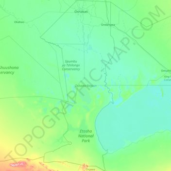
Name: Oshana topographic map, elevation, terrain.
Location: Oshana, Namibia (-19.33130 15.27904 -17.67181 16.03934)
Average elevation: 1,109 m
Minimum elevation: 1,076 m
Maximum elevation: 1,390 m
Thank you for supporting this site ❤️
Make a donation
Make a donation
Other topographic maps
Click on a map to view its topography, its elevation and its terrain.
Khorixas
Namibia > Kunene Region > Khorixas
The regional hospital and some other regional offices are located in Khorixas, though the capital of the Kunene Region is Opuwo. Khorixas has a landing strip nine kilometers east of town parallel to the C39 main road. The Runway Numbers are 09/27 and elevation is 3320 feet.
Average elevation: 974 m
Thank you for supporting this site ❤️
Make a donation
Make a donation