
Thank you for supporting this site ❤️
Make a donation
Make a donation
Pangnirtung topographic map
Click on the map to display elevation.
Thank you for supporting this site ❤️
Make a donation
Make a donation
About this map
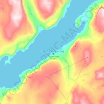
Name: Pangnirtung topographic map, elevation, terrain.
Location: Pangnirtung, Qikiqtaaluk Region, Nunavut, Canada (66.07444 -65.89661 66.21880 -65.54003)
Average elevation: 342 m
Minimum elevation: 0 m
Maximum elevation: 897 m
Thank you for supporting this site ❤️
Make a donation
Make a donation
Other topographic maps
Click on a map to view its topography, its elevation and its terrain.