
Thank you for supporting this site ❤️
Make a donation
Make a donation
Division No. 5 topographic map
Click on the map to display elevation.
Thank you for supporting this site ❤️
Make a donation
Make a donation
About this map
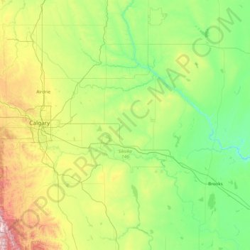
Name: Division No. 5 topographic map, elevation, terrain.
Location: Division No. 5, Alberta, Canada (50.04808 -113.73715 51.98290 -112.10745)
Average elevation: 944 m
Minimum elevation: 635 m
Maximum elevation: 2,519 m
Thank you for supporting this site ❤️
Make a donation
Make a donation
Other topographic maps
Click on a map to view its topography, its elevation and its terrain.
Thank you for supporting this site ❤️
Make a donation
Make a donation
Cochrane
Canada > Alberta > Town of Cochrane > Cochrane
Cochrane is situated at the base of Big Hill in the Bow River Valley. It sits at an elevation of 1,186 m (3,891 ft). The town is intersected by Highway 1A and Highway 22. Cochrane has a reputation for its western culture, which can easily be felt when one wanders the streets (particularly Main Street). The…
Average elevation: 1,205 m