
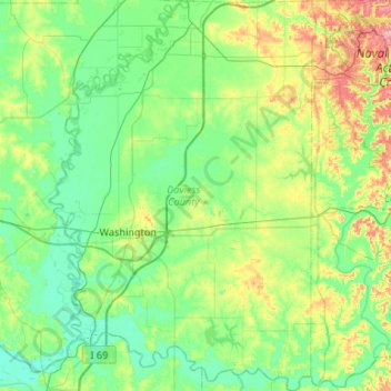
Daviess County topographic map
Interactive map
Click on the map to display elevation.
About this map
Name: Daviess County topographic map, elevation, terrain.
Location: Daviess County, Indiana, United States (38.49037 -87.27942 38.90418 -86.90423)
Average elevation: 154 m
Minimum elevation: 123 m
Maximum elevation: 251 m
The terrain of Daviess County is hilly, with its area completely devoted to agriculture or urban development. Its highest elevation (740 ft; 230 m ASL) is a rise one mile (1.6 km) NNE of Farlen. The county is drained by the White River flowing to the southwest, whose two main forks (East White and West White) come together at the county's SW corner. The county's west boundary is defined by the West White River's course and its south boundary is defined by the East White River's course; their confluence defines the county's corner point.
Other topographic maps
Click on a map to view its topography, its elevation and its terrain.
Vanderburgh County
Vanderburgh County, Indiana, United States
Average elevation: 127 m
Ohio County
Ohio County, Indiana, 47040, United States
Average elevation: 223 m
Crows Nest
United States > Indiana > Marion County
Crows Nest, Marion County, Indiana, United States
Average elevation: 229 m
Henryville
United States > Indiana > Clark County
Henryville, Clark County, Indiana, 47126, United States
Average elevation: 166 m
Jennings County
Jennings County, Indiana, United States
Average elevation: 219 m
Westport
United States > Indiana > Decatur County
Westport, Decatur County, Indiana, 47283, United States
Average elevation: 249 m
Evansville
United States > Indiana > Vanderburgh County
Evansville, Vanderburgh County, Indiana, United States
Average elevation: 122 m
Fort Wayne
United States > Indiana > Allen County > Fort Wayne
Fort Wayne, Allen County, Indiana, 46802, United States
Average elevation: 248 m
Gary
United States > Indiana > Lake County > Gary
Gary, Lake County, Indiana, 46402, United States
Average elevation: 187 m
Noblesville
United States > Indiana > Hamilton County > Noblesville
Noblesville, Hamilton County, Indiana, 46060, United States
Average elevation: 258 m
Indianapolis
United States > Indiana > Marion County
Indianapolis, Marion County, Indiana, United States
Average elevation: 241 m
Wellington
United States > Indiana > Marion County > Indianapolis
Wellington, Indianapolis, Marion County, Indiana, 46220, United States
Average elevation: 229 m
South Bend
United States > Indiana > Saint Joseph County > South Bend > Notre Dame
South Bend, Notre Dame, Saint Joseph County, Indiana, United States
Average elevation: 236 m