
Make a donation
Orange County topographic map
Click on the map to display elevation.
Make a donation
About this map
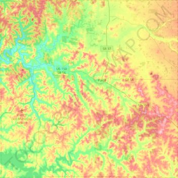
Name: Orange County topographic map, elevation, terrain.
Location: Orange County, Indiana, United States (38.39407 -86.68310 38.68866 -86.30760)
Average elevation: 210 m
Minimum elevation: 139 m
Maximum elevation: 295 m
Make a donation
Other topographic maps
Click on a map to view its topography, its elevation and its terrain.
McCormick's Creek State Park
United States > Indiana > Owen County
The heart of the park is McCormick's Creek Canyon. The upper levels of the canyon are around 700 feet (210 m) above sea levels, dropping to the west fork of the White River which is near 540 feet (160 m). The McCormick's Creek waterfall is a primary attraction of the park, as Indiana has few waterfalls due to…
Average elevation: 205 m
Fort Wayne
United States > Indiana > Allen County > Fort Wayne
The first settlement started in 1815. In 1819, the military garrison abandoned the fort and moved to Detroit. In 1822, a federal land office opened to sell land ceded by local Native Americans by the Treaty of St. Mary's in 1818. Platted in 1823 at the Ewing Tavern, the village became an important frontier…
Average elevation: 248 m
Make a donation