
Make a donation
Mazandaran Province topographic map
Click on the map to display elevation.
Make a donation
Mazandaran Province
Mazandaran province naturally comes under the influence of the geographical latitude, the Alborz mountain range, elevation from sea level, distance from the sea, and the southern barren areas of Turkmenistan, local and regional air currents, and versatile vegetation cover. These conditions result in the climatic division of the province into three types.
Make a donation
About this map
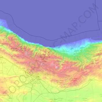
Name: Mazandaran Province topographic map, elevation, terrain.
Location: Mazandaran Province, Iran (35.76136 50.33429 37.13744 54.17297)
Average elevation: 863 m
Minimum elevation: -29 m
Maximum elevation: 5,470 m
Make a donation
Other topographic maps
Click on a map to view its topography, its elevation and its terrain.
Malham
Iran > West Azerbaijan Province > Maku County > دهستان چایباسارشمالی
Average elevation: 1,277 m
Make a donation
Qarabag
Iran > West Azerbaijan Province > Urumia County > دهستان انزل شمالی
Average elevation: 1,527 m
Kakhk
Iran > Razavi Khorasan > Gonabad County > دهستان کاخک
The city is classified as having a steppe climate with medium latitude at an altitude of 1483.26 meters above sea level. The annual temperature of the region is 17.42 degrees Celsius and 1.01% lower than the average temperature of Iran. Kakhk normally receives about 26.86 mm of rain and has 51.34 rainy days…
Average elevation: 1,634 m
Alamut Castle
Iran > Qazvin Province > Qazvin County > دهستان الموت بالا > Gazor khan
Average elevation: 2,031 m
Make a donation
Tiss Beach Resort
Iran > Sistan and Baluchestan Province > Chabahar County > دهستان وشنام دری > Tis
Average elevation: 13 m
Make a donation
Make a donation
Kelardasht
Iran > Mazandaran Province > Kelardasht County > دهستان کلاردشت غربی
Average elevation: 1,473 m
Baba Jan, East Azerbaijan
Iran > East Azerbaijan Province > Ahar County > دهستان قشلاق
Average elevation: 1,752 m
Make a donation
Masjed Soleyman
Iran > Khuzestan Province > Masjedsoleyman County > دهستان جهانگیری شمالی > Masjed Soleyman
Average elevation: 327 m
Make a donation
Make a donation
Telk Abad
Iran > Isfahan Province > Ardestan County > دهستان ریگستان > Telk Abad
Average elevation: 989 m
Make a donation
Make a donation
Make a donation