
Värmland County topographic map
Interactive map
Click on the map to display elevation.
About this map
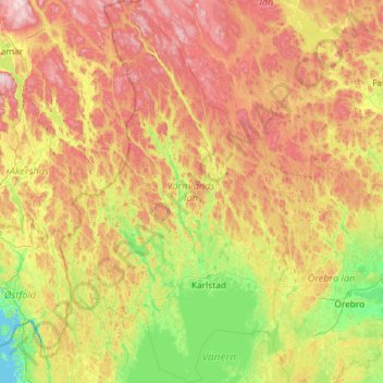
Name: Värmland County topographic map, elevation, terrain.
Location: Värmland County, Sweden (58.72533 11.69113 61.05600 14.47578)
Average elevation: 218 m
Minimum elevation: 0 m
Maximum elevation: 839 m
Other topographic maps
Click on a map to view its topography, its elevation and its terrain.
Uppsala
Situated on the fertile Uppsala flatlands of muddy soil, the city features the small Fyris River (Fyrisån) flowing through the landscape surrounded by lush vegetation. Parallel to the river runs the glacial ridge of Uppsalaåsen at an elevation around 30 m (98 ft), the site of Uppsala's castle, from which…
Average elevation: 29 m
Jönköping
Jönköping's climate was humid continental (Köppen Dfb) with long, cold winters and short, warm summers during the 1961–1990 period. However, the window between subarctic and oceanic is very small in this marine-influenced climate type, and in recent years the climate has more resembled very cold oceanic.…
Average elevation: 215 m
Örebro
Örebro, like the rest of the area close to Mälardalen, has a humid continental climate (Köppen Dfb) that is made milder by the proximity to water and the Gulf Stream which makes it interchangeable with oceanic climates. Summer temperatures occasionally exceed 30 °C (86 °F) albeit not yearly, and…
Average elevation: 59 m