
Santarém topographic map
Interactive map
Click on the map to display elevation.
About this map
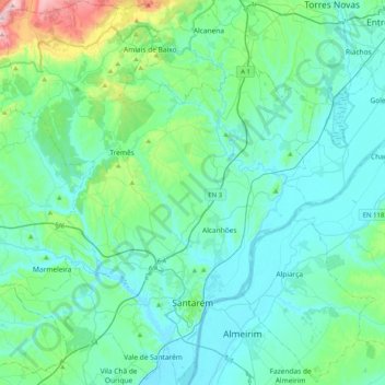
Name: Santarém topographic map, elevation, terrain.
Location: Santarém, Portugal (39.16875 -8.89945 39.48301 -8.55690)
Average elevation: 78 m
Minimum elevation: 2 m
Maximum elevation: 520 m
Other topographic maps
Click on a map to view its topography, its elevation and its terrain.
Castelo de Almourol
Portugal > Santarém > Praia do Ribatejo
Castelo de Almourol, Rua do Convento de Loreto, Praia do Ribatejo, Vila Nova da Barquinha, Santarém, 2260, Portugal
Average elevation: 63 m