
Thank you for supporting this site ❤️
Make a donation
Make a donation
Almeirim topographic map
Click on the map to display elevation.
Thank you for supporting this site ❤️
Make a donation
Make a donation
About this map
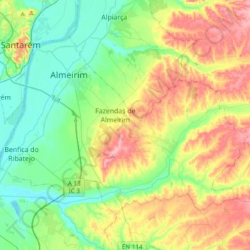
Name: Almeirim topographic map, elevation, terrain.
Location: Almeirim, Santarém, Portugal (39.09201 -8.71179 39.24398 -8.43892)
Average elevation: 60 m
Minimum elevation: 0 m
Maximum elevation: 168 m
Thank you for supporting this site ❤️
Make a donation
Make a donation
Other topographic maps
Click on a map to view its topography, its elevation and its terrain.