
Make a donation
Kochi Prefecture topographic map
Click on the map to display elevation.
Make a donation
Kochi Prefecture
Kōchi Prefecture comprises the southwestern part of the island of Shikoku, facing the Pacific Ocean. It is bordered by Ehime to the north-west and Tokushima to the north-east. It is the largest but least populous of Shikoku's four prefectures. Most of the province is mountainous, and in only a few areas such as around Kōchi and Nakamura is there a coastal plain. Kōchi is famous for its many rivers. Inamura-yama in Tosa-cho is the highest peak in Kōchi prefecture with an altitude of 1,506 meters above sea level.
Make a donation
About this map
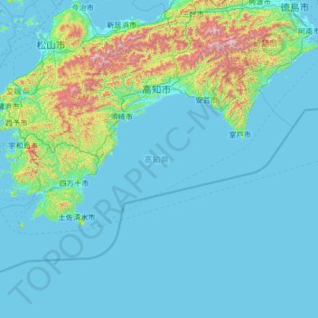
Name: Kochi Prefecture topographic map, elevation, terrain.
Location: Kochi Prefecture, Japan (32.38446 132.21266 33.88336 134.54238)
Average elevation: 155 m
Minimum elevation: -2 m
Maximum elevation: 1,883 m
Make a donation
Other topographic maps
Click on a map to view its topography, its elevation and its terrain.
Make a donation
Mt. Kumotori
Mount Kumotori (雲取山, Kumotori-san) stands at the boundary of Tokyo, Saitama, and Yamanashi Prefectures on the island of Honshū, Japan. With an elevation of 2,017 metres (6,617 ft), its summit is the highest point in Tokyo. It separates the Okutama Mountains and the Okuchichibu Mountains. While it marks…
Average elevation: 1,625 m
Make a donation