
Make a donation
Chanthaburi Province topographic map
Click on the map to display elevation.
Make a donation
Chanthaburi Province
While the southern part of the province is on the shore of the Gulf of Thailand and thus is mostly coastal alluvial plains, the interior of the province is mountainous. The Chanthaburi Mountains in the north has the highest elevation in the province, the 1,675 m high Khao Soi Dao Tai peak. The main river of the province is the Chanthaburi River. The total forest area is 2,076 km2 (802 sq mi) or 32.4 percent of provincial area. Together with the neighboring province, Trat, Chanthaburi is a center of gemstone mining, especially rubies and sapphires. Tropical fruits are also among the main products of the province. In 2000, it produced nearly 380,000 tonnes of durian, which was 45.57 percent of Thailand's durian production, approximately 27 percent of the entire world's production.
Make a donation
About this map
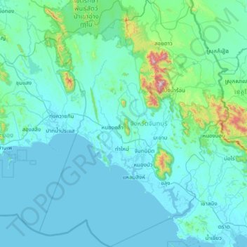
Name: Chanthaburi Province topographic map, elevation, terrain.
Location: Chanthaburi Province, Thailand (12.14743 101.59858 13.33607 102.53589)
Average elevation: 96 m
Minimum elevation: -1 m
Maximum elevation: 1,596 m
Make a donation
Other topographic maps
Click on a map to view its topography, its elevation and its terrain.
Chiang Mai
The city is situated in a valley on a river basin in the Thai highlands and is on average at 300 m (1,000 ft) elevation. Chiang Mai's city centre sits west of the Ping River, a tributary to the Chao Phraya River, while the city's sprawl extends north-west, south-west, north-east and east of the river. To the…
Average elevation: 424 m
Make a donation
Make a donation
Make a donation
Ban Ton Pho
Thailand > Pathum Thani Province > Suan Phrik Thai Subdistrict Administrative Organization > Suan Phrik Thai Subdistrict
Average elevation: 4 m
Make a donation
Ban Yai Ka Ta
Thailand > Phra Nakhon Si Ayutthaya Province > Uthai Subdistrict Administrative Organization > Uthai Subdistrict
Average elevation: 4 m
Make a donation
Bangkok
Bangkok is situated in the Chao Phraya River delta in Thailand's central plain. The river meanders through the city in a southerly direction, emptying into the Gulf of Thailand approximately 25 kilometres (16 mi) south of city centre. The area is flat and low-lying, with an average elevation of 1.5 metres (4…
Average elevation: 4 m
Make a donation
Ban Lak Khon Nuea
Thailand > Nonthaburi Province > Bang Bua Thong District > Lam Pho Subdistrict > Ban Lak Khon Nuea
Average elevation: 3 m
Make a donation
Make a donation
Make a donation