
Make a donation
Arusha topographic map
Click on the map to display elevation.
Make a donation
Arusha
The Great Rift Valley runs through the middle of the region north-to-south. Oldonyo Lengai (Mountain of God in the Maasai language) is an active volcano to the north of the Ngorongoro Conservation Area. Altitudes throughout the region vary widely, but much of it ranges from 900 to 1,600 metres (3,000 to 5,200 ft) in elevation.
Make a donation
About this map
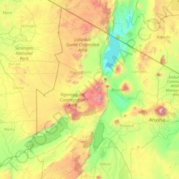
Name: Arusha topographic map, elevation, terrain.
Location: Arusha, Northern Zone, Tanzania (-4.15051 34.75004 -1.68655 37.42877)
Average elevation: 1,440 m
Minimum elevation: 594 m
Maximum elevation: 4,271 m
Make a donation
Other topographic maps
Click on a map to view its topography, its elevation and its terrain.
Make a donation
Babati
Babati town has developed from a mere village since Babati District was established in 1985. The new status boosted the town into rapid growth. The town is located at an altitude of 2,145 metres or 7,037 feet near the end of Tarangire National Park and the base of Lake Babati, nestling under Mount Kwaraha.
Average elevation: 1,392 m
Make a donation
Make a donation
Make a donation
Make a donation
Make a donation
Njombe
Njombe is a town in southern Tanzania. It is the regional capital of Njombe Region as well as the district headquarter of Njombe Rural District and Njombe Urban District. It is located at nearly 2000 meters of altitude on the eastern edge of the Kipengere Range and has the reputation of being a cold town.
Average elevation: 1,888 m
Make a donation
Make a donation
Make a donation
Make a donation
Make a donation
Make a donation
Make a donation
Make a donation
Make a donation
Make a donation
Make a donation
Make a donation
Make a donation
Make a donation
Make a donation
Make a donation
Make a donation
Make a donation
Make a donation