
White Top topographic map
Interactive map
Click on the map to display elevation.
About this map
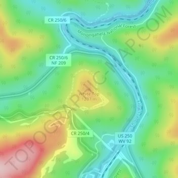
Name: White Top topographic map, elevation, terrain.
Location: White Top, Randolph County, West Virginia, United States (38.62451 -79.87678 38.62461 -79.87668)
Average elevation: 1,159 m
Minimum elevation: 1,072 m
Maximum elevation: 1,318 m
White Top is a knob and spur of Cheat Mountain in southeastern Randolph County, West Virginia, USA. Sitting at an elevation of 4,085 feet (1,245 m), it is located just west of the Shavers Fork of Cheat River and Cheat Bridge. While White Top was originally crossed by the Staunton–Parkersburg Turnpike, modern-day U.S. Route 250 skirts the base of the knob beside Shavers Fork to the north and east.
Other topographic maps
Click on a map to view its topography, its elevation and its terrain.
Osceola
United States > West Virginia > Randolph County
Osceola, Randolph County, West Virginia, 26296, United States
Average elevation: 1,123 m
Elkins
United States > West Virginia > Randolph County
Elkins, Randolph County, West Virginia, 26241, United States
Average elevation: 637 m
Bemis
United States > West Virginia > Randolph County
Bemis, Randolph County, West Virginia, 26268, United States
Average elevation: 958 m
Glady
United States > West Virginia > Randolph County
Glady, Randolph County, West Virginia, 26268, United States
Average elevation: 943 m
Montrose
United States > West Virginia > Randolph County
Montrose, Randolph County, West Virginia, United States
Average elevation: 630 m
Whitmer
United States > West Virginia > Randolph County
Whitmer, Randolph County, West Virginia, United States
Average elevation: 972 m
Mill Creek
United States > West Virginia > Randolph County
Mill Creek, Randolph County, West Virginia, United States
Average elevation: 651 m
Adolph
United States > West Virginia > Randolph County
Adolph, Randolph County, West Virginia, 26280, United States
Average elevation: 821 m
Kumbrabow State Forest
United States > West Virginia > Randolph County
Kumbrabow State Forest, Randolph County, West Virginia, United States
Average elevation: 1,013 m
Harman
United States > West Virginia > Randolph County > Harman
Harman, Randolph County, West Virginia, 26760, United States
Average elevation: 814 m
Blue Spring
United States > West Virginia > Randolph County
Blue Spring, Randolph County, West Virginia, 26282, United States
Average elevation: 939 m
Bickle Knob
United States > West Virginia > Randolph County
Bickle Knob, Randolph County, West Virginia, United States
Average elevation: 982 m
Valley Head
United States > West Virginia > Randolph County > Valley Head
Valley Head, Randolph County, West Virginia, 26294, United States
Average elevation: 874 m
Dryfork
United States > West Virginia > Randolph County > Dryfork
Dryfork, Randolph County, West Virginia, 26289, United States
Average elevation: 755 m
Pumpkintown
United States > West Virginia > Randolph County
Pumpkintown, Randolph County, West Virginia, 26278, United States
Average elevation: 743 m