
Thank you for supporting this site ❤️
Make a donation
Make a donation
Montrose topographic map
Click on the map to display elevation.
Thank you for supporting this site ❤️
Make a donation
Make a donation
About this map
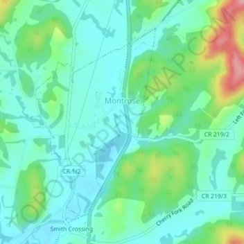
Name: Montrose topographic map, elevation, terrain.
Location: Montrose, Randolph County, West Virginia, United States (39.05563 -79.82341 39.07649 -79.80564)
Average elevation: 630 m
Minimum elevation: 596 m
Maximum elevation: 730 m
Thank you for supporting this site ❤️
Make a donation
Make a donation
Other topographic maps
Click on a map to view its topography, its elevation and its terrain.
Thank you for supporting this site ❤️
Make a donation
Make a donation
Bickle Knob
United States > West Virginia > Randolph County
Bickle Knob is located at the end of Forest Route 91A, a spur from Stuart Memorial Drive (FR 91). Both roads are gravel but can easily be traversed by normal passenger cars. Stuart Memorial Drive is a scenic path as it traces the edge of the Shavers Fork canyon. Due to the high elevation of the area and the…
Average elevation: 982 m
Thank you for supporting this site ❤️
Make a donation
Make a donation