
Thank you for supporting this site ❤️
Make a donation
Make a donation
Whitmer topographic map
Click on the map to display elevation.
Thank you for supporting this site ❤️
Make a donation
Make a donation
About this map
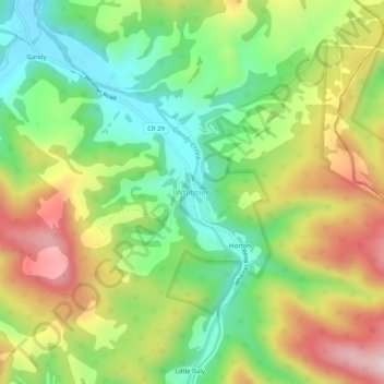
Name: Whitmer topographic map, elevation, terrain.
Location: Whitmer, Randolph County, West Virginia, United States (38.79289 -79.56894 38.83289 -79.52894)
Average elevation: 972 m
Minimum elevation: 807 m
Maximum elevation: 1,192 m
Thank you for supporting this site ❤️
Make a donation
Make a donation
Other topographic maps
Click on a map to view its topography, its elevation and its terrain.