
Olen topographic map
Interactive map
Click on the map to display elevation.
About this map
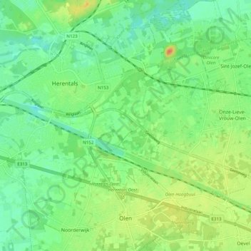
Name: Olen topographic map, elevation, terrain.
Location: Olen, Turnhout, Antwerp, Flanders, 2250, Belgium (51.13583 4.84014 51.19689 4.92673)
Average elevation: 17 m
Minimum elevation: 2 m
Maximum elevation: 41 m
Other topographic maps
Click on a map to view its topography, its elevation and its terrain.
Voortkapel
Belgium > Antwerp > Turnhout > Westerlo
Voortkapel, Westerlo, Turnhout, Antwerp, 2260, Belgium
Average elevation: 15 m
Herenthout
Belgium > Antwerp > Turnhout > Herenthout
Herenthout, Turnhout, Antwerp, Flanders, 2270, Belgium
Average elevation: 10 m
Hoogstraten
Belgium > Antwerp > Turnhout > Hoogstraten
Hoogstraten, Turnhout, Antwerp, Flanders, 2320, Belgium
Average elevation: 19 m