
Réunion topographic map
Interactive map
Click on the map to display elevation.
About this map
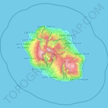
Name: Réunion topographic map, elevation, terrain.
Location: Réunion, France (-21.59045 55.00328 -20.67276 56.05079)
Average elevation: 186 m
Minimum elevation: 0 m
Maximum elevation: 3,014 m
Already at the time of the India Route or Route des Indes, Réunion was a French possession located between Cape Town and the Indian trading posts, although far from the Mozambique Channel. Île de Bourbon (its name under the Ancien Régime) was not, however, the preferred position for trade and military. Governor Labourdonnais claimed that Île de France (Mauritius) was a land of opportunity, thanks to its topography and the presence of two natural harbours. He intended Île de Bourbon to be a depot or an emergency base for Île de France.
Other topographic maps
Click on a map to view its topography, its elevation and its terrain.
Manjotier
France > Auvergne-Rhône-Alpes > Isère > Miribel-les-Échelles
Manjotier, Miribel-les-Échelles, Grenoble, Isère, Auvergne-Rhône-Alpes, Metropolitan France, 38380, France
Average elevation: 618 m
Rencurel
France > Auvergne-Rhône-Alpes > Isère
Rencurel, Grenoble, Isère, Auvergne-Rhône-Alpes, Metropolitan France, 38680, France
Average elevation: 1,099 m
Le Grand-Lemps
France > Auvergne-Rhône-Alpes > Isère
Le Grand-Lemps, La Tour-du-Pin, Isère, Auvergne-Rhône-Alpes, Metropolitan France, 38690, France
Average elevation: 512 m
city de boutet de monvel (ethanlecartographe
France > Grand Est > Meurthe-et-Moselle > Lunéville
city de boutet de monvel (ethanlecartographe, Lunéville, Meurthe-et-Moselle, Grand Est, Metropolitan France, 54300, France
Average elevation: 240 m
Isère
Isère, Auvergne-Rhône-Alpes, Metropolitan France, France
Average elevation: 868 m
Rambe
France > Auvergne-Rhône-Alpes > Puy-de-Dôme > Peschadoires
Rambe, Peschadoires, Thiers, Puy-de-Dôme, Auvergne-Rhône-Alpes, Metropolitan France, 63920, France
Average elevation: 361 m
Quéant
France > Hauts-de-France > Pas-de-Calais
Quéant, Arras, Pas-de-Calais, Hauts-de-France, Metropolitan France, 62860, France
Average elevation: 85 m
Fontaine
France > Auvergne-Rhône-Alpes > Isère
Fontaine, Grenoble, Isère, Auvergne-Rhône-Alpes, Metropolitan France, 38600, France
Average elevation: 253 m
Le Born
France > Occitania > Haute-Garonne
Le Born, Toulouse, Haute-Garonne, Occitania, Metropolitan France, 31340, France
Average elevation: 169 m
Noreuil
France > Hauts-de-France > Pas-de-Calais
Noreuil, Arras, Pas-de-Calais, Hauts-de-France, Metropolitan France, 62128, France
Average elevation: 97 m
Montagnole
France > Auvergne-Rhône-Alpes > Savoy
Montagnole, Chambéry, Savoy, Auvergne-Rhône-Alpes, Metropolitan France, 73000, France
Average elevation: 685 m
Mézos
France > Nouvelle-Aquitaine > Landes
Mézos, Mont-de-Marsan, Landes, Nouvelle-Aquitaine, Metropolitan France, 40170, France
Average elevation: 40 m
Village Tumukuru
France > French Polynesia > Tatakoto
Village Tumukuru, Tatakoto, Tuamotu-Gambier, French Polynesia, 98783, France
Average elevation: 1 m
Champniers
France > Nouvelle-Aquitaine > Charente
Champniers, Angoulême, Charente, Nouvelle-Aquitaine, Metropolitan France, 16430, France
Average elevation: 92 m
Montferrand
Montferrand, Carcassonne, Aude, Occitania, Metropolitan France, 11320, France
Average elevation: 222 m
Ain
Ain, Auvergne-Rhône-Alpes, Metropolitan France, France
Average elevation: 418 m
Rangiroa
France > French Polynesia > Rangiroa
Rangiroa, Tuamotu-Gambier, French Polynesia, 98775, France
Average elevation: 0 m
Maine-et-Loire
Maine-et-Loire, Pays de la Loire, Metropolitan France, France
Average elevation: 76 m
Custines
France > Grand Est > Meurthe-et-Moselle
Custines, Nancy, Meurthe-et-Moselle, Grand Est, Metropolitan France, 54670, France
Average elevation: 275 m
Sus
France > Nouvelle-Aquitaine > Pyrénées-Atlantiques
Sus, Oloron-Sainte-Marie, Pyrénées-Atlantiques, Nouvelle-Aquitaine, Metropolitan France, 64190, France
Average elevation: 162 m
Domaine de Saint-Lambert
France > Occitania > Lozère > Marvejols
Domaine de Saint-Lambert, Promenade Louis Cabanettes, Marvejols, Mende, Lozère, Occitania, Metropolitan France, 48100, France
Average elevation: 725 m
Pregnin
France > Auvergne-Rhône-Alpes > Ain > Saint-Genis-Pouilly
Pregnin, Saint-Genis-Pouilly, Gex, Ain, Auvergne-Rhône-Alpes, Metropolitan France, 01630, France
Average elevation: 473 m
Saint-Pierre-de-Cernières
Saint-Pierre-de-Cernières, Bernay, Eure, Normandy, Metropolitan France, 27390, France
Average elevation: 201 m
Le Not
France > Auvergne-Rhône-Alpes > Isère > Saint-Hilaire-de-la-Côte
Le Not, Saint-Hilaire-de-la-Côte, Vienne, Isère, Auvergne-Rhône-Alpes, Metropolitan France, 38260, France
Average elevation: 406 m
Entrange Cité
Entrange Cité, Entrange, Thionville, Moselle, Grand Est, Metropolitan France, 57330, France
Average elevation: 237 m
Saint-Nazaire
France > Pays de la Loire > Loire-Atlantique
Saint-Nazaire, Loire-Atlantique, Pays de la Loire, Metropolitan France, 44600, France
Average elevation: 6 m
Cachar
France > Occitania > Gard > Saint-Jean-du-Gard
Cachar, Saint-Jean-du-Gard, Alès, Gard, Occitania, Metropolitan France, 30270, France
Average elevation: 312 m
Mandrel
France > Grand Est > Aube > Lignol-le-Château
Mandrel, Lignol-le-Château, Bar-sur-Aube, Aube, Grand Est, Metropolitan France, 10200, France
Average elevation: 262 m
Sénestis
France > Nouvelle-Aquitaine > Lot-et-Garonne
Sénestis, Marmande, Lot-et-Garonne, Nouvelle-Aquitaine, Metropolitan France, 47430, France
Average elevation: 32 m
Entremont
France > Auvergne-Rhône-Alpes > Upper Savoy > Glières-Val-de-Borne
Entremont, Glières-Val-de-Borne, Bonneville, Upper Savoy, Auvergne-Rhône-Alpes, Metropolitan France, 74130, France
Average elevation: 1,302 m
Juan de Nova Island
France > French Southern and Antarctic Lands
Juan de Nova Island, Scattered Islands in the Indian Ocean, French Southern and Antarctic Lands, France
Average elevation: 0 m
Mane
France > Occitania > Haute-Garonne
Mane, Saint-Gaudens, Haute-Garonne, Occitania, Metropolitan France, 31260, France
Average elevation: 338 m
Massongy
France > Auvergne-Rhône-Alpes > Upper Savoy
Massongy, Thonon-les-Bains, Upper Savoy, Auvergne-Rhône-Alpes, Metropolitan France, 74140, France
Average elevation: 454 m
Vensac
France > Nouvelle-Aquitaine > Gironde
Vensac, Lesparre-Médoc, Gironde, Nouvelle-Aquitaine, Metropolitan France, 33590, France
Average elevation: 4 m
Nocha
France > Grand Est > Vosges > Autreville
Nocha, Autreville, Neufchâteau, Vosges, Grand Est, Metropolitan France, 88300, France
Average elevation: 309 m