
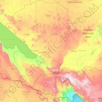
Mbeya Region topographic map
Interactive map
Click on the map to display elevation.
About this map
Name: Mbeya Region topographic map, elevation, terrain.
Location: Mbeya Region, Southern Highlands Zone, Tanzania (-9.71887 32.89446 -6.86722 34.96885)
Average elevation: 1,314 m
Minimum elevation: 473 m
Maximum elevation: 2,901 m
The Great Rift Valley created the majority of the places in the area, with the lowland elevation occupying the Western Rift Zone, which includes the Lake Rukwa and Lake Nyasa regions, and the Eastern Rift Zone, which includes the Usangu Plains and other sections of the Ruaha Trough. The heights range from 475 meters above sea level at Lake Nyasa to more than 2,900 meters at Mount Rungwe's summit.
Other topographic maps
Click on a map to view its topography, its elevation and its terrain.
Iramba
Iramba, Ushetu, Shinyanga Region, Lake Zone, Tanzania
Average elevation: 1,210 m
Lusonga
Lusonga, Songea, Ruvuma Region, Southern Highlands Zone, Tanzania
Average elevation: 931 m
Nungwi
Nungwi, Kaskazini A, Zanzibar North, Zanzibar, 73107, Tanzania
Average elevation: 5 m
Mwanza
Mwanza, Nyamagana, Mwanza Region, Lake Zone, 33214, Tanzania
Average elevation: 1,178 m
Dodoma
Dodoma, Dodoma City, Dodoma Region, Central Zone, Tanzania
Average elevation: 1,144 m
Kilino
Kilino, Nzega, Tabora Region, Central Zone, Tanzania
Average elevation: 1,242 m
Ibadakuli
Ibadakuli, Shinyanga Urban, Shinyanga Region, Lake Zone, Tanzania
Average elevation: 1,156 m
Chindi
Tanzania > Songwe Region > Chindi
Chindi, Momba, Songwe Region, Southern Highlands Zone, Tanzania
Average elevation: 1,035 m
Furtwängler Glacier
Furtwängler Glacier, Scree Slope, Rombo, Kilimanjaro, Northern Zone, Tanzania
Average elevation: 5,569 m
Udzungwa National Park
Tanzania > Morogoro > Ruaha Darajani
Udzungwa National Park, Iringa Road, Ruaha Darajani, Kilosa, Morogoro, Coastal Zone, Tanzania
Average elevation: 760 m
Pemba
Pemba, Chake-Chake District, South Pemba, Zanzibar, Tanzania
Average elevation: 4 m
Moshi
Moshi, Moshi Urban, Kilimanjaro, Northern Zone, 25107, Tanzania
Average elevation: 1,109 m
Machame
Tanzania > Kilimanjaro > Machame
Machame, Hai, Kilimanjaro, Northern Zone, Tanzania
Average elevation: 1,417 m
Kijitonyama
Tanzania > Coastal Zone > Dar es Salaam
Kijitonyama, Dar es Salaam, Coastal Zone, Tanzania
Average elevation: 26 m
sirori simba
Tanzania > Mara > sirori simba
sirori simba, Musoma, Mara, Lake Zone, Tanzania
Average elevation: 1,345 m
Mawenzi
Mawenzi, Rombo, Kilimanjaro, Northern Zone, Tanzania
Average elevation: 4,479 m
Kinondoni
Tanzania > Coastal Zone > Dar es Salaam
Kinondoni, Dar es Salaam, Coastal Zone, Tanzania
Average elevation: 12 m
Lushoto
Lushoto, Tanga Region, Northern Zone, Tanzania
Average elevation: 1,492 m
Lake Manyara
Lake Manyara, Babati, Manyara, Northern Zone, Tanzania
Average elevation: 1,174 m
Mount Meru
Mount Meru, Arumeru, Arusha, Northern Zone, Tanzania
Average elevation: 3,884 m
Tungi
Tungi, Kigamboni Municipal, Dar es Salaam, Coastal Zone, Tanzania
Average elevation: 8 m