
Mwanga topographic map
Interactive map
Click on the map to display elevation.
About this map
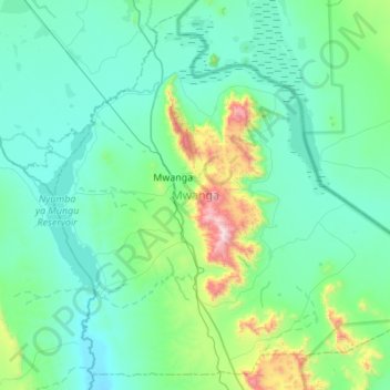
Name: Mwanga topographic map, elevation, terrain.
Location: Mwanga, Kilimanjaro, Northern Zone, Tanzania (-3.93960 37.41032 -3.43341 37.95635)
Average elevation: 843 m
Minimum elevation: 650 m
Maximum elevation: 2,088 m
Other topographic maps
Click on a map to view its topography, its elevation and its terrain.
Furtwängler Glacier
Furtwängler Glacier, Scree Slope, Rombo, Kilimanjaro, Northern Zone, Tanzania
Average elevation: 5,569 m
Moshi
Moshi, Moshi Urban, Kilimanjaro, Northern Zone, 25107, Tanzania
Average elevation: 1,109 m
Machame
Tanzania > Kilimanjaro > Machame
Machame, Hai, Kilimanjaro, Northern Zone, Tanzania
Average elevation: 1,417 m
Mawenzi
Mawenzi, Rombo, Kilimanjaro, Northern Zone, Tanzania
Average elevation: 4,479 m