
Secunderabad topographic map
Interactive map
Click on the map to display elevation.
Secunderabad
Situated in the North of Hyderabad at 17°27′N 78°30′E / 17.45°N 78.5°E / 17.45; 78.5., Secunderabad lies on the northern part of the Deccan Plateau. Secunderabad has an average elevation of 543 metres (1781 ft). Most of the area has a rocky terrain and some areas are hilly.
About this map
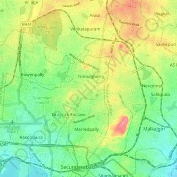
Name: Secunderabad topographic map, elevation, terrain.
Location: Secunderabad, Hyderabad, Telangana, 500003, India (17.27372 78.34068 17.59372 78.66068)
Average elevation: 544 m
Minimum elevation: 446 m
Maximum elevation: 634 m
Other topographic maps
Click on a map to view its topography, its elevation and its terrain.
Hyderabad
India > Telangana > Bahadurpura mandal
Hyderabad (/ˈhaɪdərəbæd/ HY-dər-ə-bad; Telugu: [ˈɦaɪ̯daraːbaːd], Urdu: [ˈɦɛːdəɾaːbaːd]) is the capital and largest city of the Indian state of Telangana. It occupies 650 km2 (250 sq mi) on the Deccan Plateau along the banks of the Musi River, in the northern part of Southern India. With an…
Average elevation: 549 m
Link-I (Kaleshwaram Lift Irrigation Project, North Part)
India > Telangana > Anthergaon mandal > Goilwada
Average elevation: 144 m
Hyderabad
India > Telangana > Bahadurpura mandal
Hyderabad (Telugu: Haidarābād , pronounced [ˈɦaɪ̯dəɾaːbaːd]; Urdu: [ˈɦɛːdəɾaːbaːd]) is the capital and largest city of the Indian state of Telangana. It occupies 650 km2 (250 sq mi) on the Deccan Plateau along the banks of the Musi River, in the northern part of Southern India. With an…
Average elevation: 549 m
Nallamala Hills
The Nallamalas (also called the Nallamalla Range) are a section of the Eastern Ghats which forms the eastern boundary of Rayalaseema region of the state of Andhra Pradesh and Mahabubnagar, Nalgonda districts of the state of Telangana, in India. They run in a nearly north-south alignment, parallel to the…
Average elevation: 278 m
Sri Komaravelli Mallanna Sagar
India > Telangana > Thoguta mandal > Thukkapur
Average elevation: 542 m