Geolocate

Ward 105 Gachibowli topographic map

Interactive map

Click on the map to display elevation.

About this map

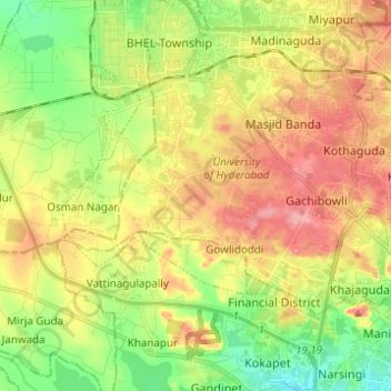
Name: Ward 105 Gachibowli topographic map, elevation, terrain.

Location: Ward 105 Gachibowli, Greater Hyderabad Municipal Corporation West Zone, Hyderabad, Serilingampalle mandal, Rangareddy, Telangana, India (17.40955 78.27175 17.48075 78.39495)

Average elevation: 568 m

Minimum elevation: 517 m

Maximum elevation: 625 m

Other topographic maps

Click on a map to view its topography, its elevation and its terrain.

Musi River

India > Telangana > Hyderabad

Average elevation: 490 m

Kappala Cheruvu

India > Telangana > Hyderabad

Average elevation: 537 m

Kapra lake

India > Telangana > Hyderabad

Average elevation: 557 m

Pedda Cheruvu

India > Telangana > Hyderabad

Average elevation: 550 m

Geological Survey of India

India > Telangana > Hyderabad

Average elevation: 502 m

Alwal Lake

India > Telangana > Hyderabad

Average elevation: 576 m

Musi

India > Telangana > Hyderabad

Average elevation: 522 m

Shilparamam

India > Telangana > Hyderabad

Average elevation: 586 m

Qutub Shahi Tombs

India > Telangana > Hyderabad

Average elevation: 538 m