
Make a donation
Pangi topographic map
Click on the map to display elevation.
Make a donation
About this map
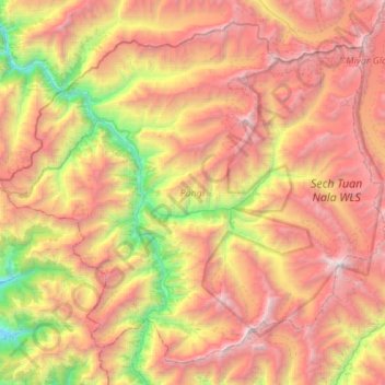
Name: Pangi topographic map, elevation, terrain.
Location: Pangi, Chamba District, Himachal Pradesh, 176323, India (32.80122 76.23220 33.20898 76.78042)
Average elevation: 4,082 m
Minimum elevation: 1,893 m
Maximum elevation: 6,413 m
Make a donation
Other topographic maps
Click on a map to view its topography, its elevation and its terrain.
Make a donation
Keylang
India > Himachal Pradesh > Lahaul
Kyelang is accessible from Manali via the Manali-Leh Highway, a part of NH21. It is located about 71 km (44 mi) north of Manali at an altitude of 3,080 m (10,100 ft) and used to remain cut off from the outside world for six months from late October to mid-May due to heavy snowfall at Rohtang pass until the…
Average elevation: 3,823 m
Make a donation
Dharamshala
India > Himachal Pradesh > Dharamshala
Dharamshala has an average elevation of 1,457 m (4,780 ft), covering an area of almost 8.51 km2 (3.29 sq mi). Dharamsala is located in the Kangra Valley, in the shadow of the Dhauladhar mountains.
Average elevation: 1,781 m
Make a donation
Shimla
India > Himachal Pradesh > Shimla (urban)
Shimla is on the south-western ranges of the Himalayas at 31°37′N 77°06′E / 31.61°N 77.10°E / 31.61; 77.10. It has an average altitude of 2,206 metres (7,238 ft) above mean sea level and extends along a ridge with seven spurs. The city stretches nearly 9.2 kilometres (5.7 mi) from east to west.
Average elevation: 1,557 m
Make a donation
Make a donation
Rewalsar
India > Himachal Pradesh > Mandi
Rewalsar is located at an altitude of 1360 m above sea level. It is connected to Mandi by a motorable road and is about 25 km from Mandi. Lying in the Southern Himalayan belt, winters in Rewalsar can be freezing, while summers are generally pleasant.
Average elevation: 1,283 m
Make a donation
Make a donation
Sarahan
India > Himachal Pradesh > Rampur
Sarahan is located at 31°31′N 77°48′E / 31.52°N 77.80°E / 31.52; 77.80. It has an average elevation of 2,313 metres (7,589 feet).
Average elevation: 2,204 m
Make a donation
Make a donation
Darcha
India > Himachal Pradesh > Lahul
Darcha (elevation 3,360 m or 11,020 ft) is a pair of villages (Darcha Sumdo and Darach Dangma) on the Bhaga River in the Lahaul sub-division in the Lahaul and Spiti district in the Indian state of Himachal Pradesh. It is the northernmost permanent settlement in Himachal Pradesh along the Manali-Leh Highway.…
Average elevation: 3,702 m
Make a donation
Make a donation
Make a donation
Make a donation
Solan
India > Himachal Pradesh > Solan
Solan is a city in the Indian state of Himachal Pradesh and the district headquarters of Solan district. It is located 45.5 kilometres (28 mi) south of the state capital, Shimla. Solan has an average elevation of 1,550 metres (5,090 ft). The city is situated between Chandigarh (joint capital of Punjab and…
Average elevation: 1,312 m
Make a donation
Make a donation
Make a donation
Indrasan
India > Himachal Pradesh > Lahul
Mount Indrasan is located at an altitude of 6221 metres above sea level in Kullu district, Himachal Pradesh. Mt. Indrasan is considered as the most difficult mountain to climb in the Pir Panjal range of the Himalayas because of the challenges involved in scaling it. It was first climbed on October 13, 1962, by…
Average elevation: 5,374 m
Make a donation
Make a donation
Make a donation
Make a donation