
Make a donation
Bangalore South topographic map
Click on the map to display elevation.
Make a donation
About this map
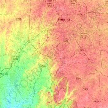
Name: Bangalore South topographic map, elevation, terrain.
Location: Bangalore South, Bengaluru Urban, Karnataka, India (12.73168 77.32553 12.99643 77.68786)
Average elevation: 846 m
Minimum elevation: 657 m
Maximum elevation: 1,026 m
Make a donation
Other topographic maps
Click on a map to view its topography, its elevation and its terrain.
Mysuru
India > Karnataka > Mysuru taluk
Mysore (/maɪˈsɔːr/ (listen)), officially Mysuru ([ˈmaɪˈsuːɾu] (listen)), is a city in the southern part of the state of Karnataka, India. Mysore city is geographically located between 12° 18′ 26″ north latitude and 76° 38′ 59″ east longitude. It is located at an altitude of 770 m (2,530 ft)…
Average elevation: 727 m
Make a donation
Puttur
India > Karnataka > Putturu taluk
Puttur is located at 12°45′53″N 75°11′03″E / 12.7648°N 75.1842°E / 12.7648; 75.1842. It has an average elevation of 87 m (300 ft). Puttur is situated 52 km (32 mi) south-east of Mangalore city.
Average elevation: 110 m
Make a donation
Make a donation
Mangaluru
India > Karnataka > Mangaluru taluk
Mangalore is also the administrative headquarters of the Dakshina Kannada district; it is a commercial, industrial, educational, healthcare, and startup hub. The city's international airport is the second-largest and second-busiest airport in Karnataka. Mangalore City Corporation is responsible for the civic…
Average elevation: 25 m
Make a donation
Make a donation
Sirsi
India > Karnataka > Shirasi taluk
Sirsi is located at 14°37′N 74°51′E / 14.62°N 74.85°E / 14.62; 74.85. It has an elevation ranging between 1860 feet to 2600 feet above sea level, and is situated in the heart of the Western Ghats. The River Aghanashini begins near Sirsi called Shankara Honda and flows towards the Arabian Sea…
Average elevation: 580 m
Make a donation
Bagepalli
India > Karnataka > Bagepalli taluk
Bagepalli is located at 13°47′N 77°47′E / 13.78°N 77.79°E / 13.78; 77.79. It has an average elevation of 707 metres (2319 ft).
Average elevation: 730 m
Chikkaballapura
India > Karnataka > Chikkaballapura taluk
Chikkaballapur has a high elevation located in the center of the Nandi Hills region. "Panchagiri" is a common descriptor of Chikkaballapur as it is surrounded by 5 hills, among which Nandi Hill is the most famous. (the five hills are Nandi Giri, Chandra Giri, Skandagiri, Brahma Giri, and Hema Giri).
Average elevation: 929 m
Make a donation
Gundlupet
India > Karnataka > Gundlupet taluk
Gundlupet is located at 11°48′N 76°41′E / 11.8°N 76.68°E / 11.8; 76.68. It has an average elevation of 816 metres (2,677 feet).
Average elevation: 807 m
Udupi
India > Karnataka > Udupi taluku
Udupi has an elevation of 27 m (89 ft) above mean sea level. The climate in Udupi is hot in summers and pleasant in winter. During summers (from March to May) the temperature reaches up to 38 °C (100 °F) and in winters (from December to February) it is usually between 32 and 20 °C (90 and 68 °F). As it is…
Average elevation: 17 m
Make a donation
Kunigal
India > Karnataka > Kunigal taluk
Kunigal is located at 13°01′N 77°02′E / 13.02°N 77.03°E / 13.02; 77.03. It has an average elevation of 773 metres (2536 feet). It is situated on the National Highway 75 (India) connecting Bengaluru and Mangaluru and State Highway 33 (Karnataka) connecting Tumakuru and Madduru. Kunigal is…
Average elevation: 775 m
Make a donation
Make a donation
Madhugiri
India > Karnataka > Madhugiri taluk
Madhugiri is located at 13°40′N 77°13′E / 13.66°N 77.21°E / 13.66; 77.21. It has an average elevation of 787 metres (2582 feet).
Average elevation: 783 m
Make a donation
Magadi
India > Karnataka > Magadi taluku
Magadi is located at 12°58′N 77°14′E / 12.97°N 77.23°E / 12.97; 77.23. It has an average elevation of 925 metres (3034 feet).
Average elevation: 872 m
Krishnarajapete
India > Karnataka > Krishnarajapete taluk
Krishnarajpet is located at 12°40′N 76°29′E / 12.66°N 76.49°E / 12.66; 76.49. It has an average elevation of 790 metres (2591 feet).
Average elevation: 819 m
Manipal
India > Karnataka > Udupi taluku
Manipal (Kannada: [mɐɳipaːlɐ]) is a suburb and university town within Udupi, in coastal Karnataka, India. Manipal is located five kilometres away from the centre of Udupi City, in Udupi District, Karnataka (state) in south western India. It is administered by the Udupi City Municipality. The suburb is…
Average elevation: 32 m
Make a donation
Mulabagilu
India > Karnataka > Mulubagilu taluk
Mulabagilu is located at 13°10′N 78°24′E / 13.17°N 78.4°E / 13.17; 78.4. It has an average elevation of 827 metres (2,713 feet).
Average elevation: 822 m
Make a donation
Tumakuru
India > Karnataka > Tumkur taluk
Another story says that during the rule of cholas Gulur was their capital. Since Tumkur is at high elevation the guards used to be there on any hill with tumaki (a kind of drum) and used to make sound in case of any alerts, hence the name. The Indian central government approved the request to officially rename…
Average elevation: 838 m
Make a donation
Make a donation
Bhadravathi
India > Karnataka > Bhadravati taluk
Bhadravati is at an altitude of 597 metres (1,959 ft) above sea level.
Average elevation: 642 m
Make a donation
Mysuru
India > Karnataka > Mysuru taluk
Mysore is situated at the foothills of the Chamundi Hills. At an altitude of 770 m (2,530 ft) above mean sea level, the city of Mysore is geographically located at 12° 18′ 26″ north latitude and 76° 38′ 59″ east longitude. It is about 140 km (87.0 mi) southwest of the state's capital, Bangalore, and…
Average elevation: 727 m
Make a donation
Kalaburagi
India > Karnataka > Kalaburagi taluku
The entire district is on the Deccan Plateau, and the elevation ranges from 300 to 750 m above MSL. Two main rivers, the Krishna and Bhima, flow through the district. The predominant soil type is black soil. The district has many tanks, which irrigate the land along with the river. The Upper Krishna Project is…
Average elevation: 465 m
Bhadravathi
India > Karnataka > Bhadravati taluk
Bhadravati is at an altitude of 597 metres (1,959 ft) above sea level.
Average elevation: 642 m
Make a donation
Makanahalli Kere
India > Karnataka > Tirumakudalu Narasipura taluk > Makanahalli
Average elevation: 678 m
Mangaluru
India > Karnataka > Mangaluru taluk
Mangaluru is included as one of the cities in the Smart Cities Mission list and is among the 100 smart cities to be developed in India. It has an average elevation of 22 m (72 ft) above mean sea level. It has a tropical monsoon climate and is under the influence of the southwest monsoon. It has its own…
Average elevation: 25 m
Make a donation
Bengaluru
India > Karnataka > Bangalore North
Bengaluru lies in the southeast of the South Indian state of Karnataka in the heart of the Mysore Plateau (a region of the larger Deccan Plateau) at an average elevation of 900 m (2,953 ft). The city covers an area of 741 km2 (286 sq mi). The Bengaluru metropolitan region covers an area of 7,005 km2 (2,705 sq…
Average elevation: 879 m
Hunsur
India > Karnataka > Hunasuru taluk
Hunsur is located at 12°19′N 76°17′E / 12.31°N 76.29°E / 12.31; 76.29. It is located at an elevation of 805 metres (2,641 ft) above mean sea level. The river Lakshmana Tirtha flows through the town and two bridges are built across the river. The town is the administrative center of Hunsur…
Average elevation: 792 m
Make a donation