
Make a donation
Chikkaballapura topographic map
Click on the map to display elevation.
Make a donation
Chikkaballapura
Chikkaballapur has a high elevation located in the center of the Nandi Hills region. "Panchagiri" is a common descriptor of Chikkaballapur as it is surrounded by 5 hills, among which Nandi Hill is the most famous. (the five hills are Nandi Giri, Chandra Giri, Skandagiri, Brahma Giri, and Hema Giri).
Make a donation
About this map
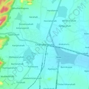
Name: Chikkaballapura topographic map, elevation, terrain.
Average elevation: 929 m
Minimum elevation: 894 m
Maximum elevation: 1,220 m
Make a donation
Other topographic maps
Click on a map to view its topography, its elevation and its terrain.
Nandi Hills State Forest
India > Karnataka > Chikkaballapura taluk > Suddahalli
Average elevation: 865 m
Nandi Hills State Forest
India > Karnataka > Chikkaballapura taluk > Kanivenarayanapura
Average elevation: 853 m
Nandi Hills State Forest
India > Karnataka > Chikkaballapura taluk > Kanivenarayanapura
Average elevation: 853 m