
Bhuj Taluka topographic map
Interactive map
Click on the map to display elevation.
About this map
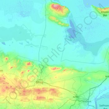
Name: Bhuj Taluka topographic map, elevation, terrain.
Location: Bhuj Taluka, Kachchh, Gujarat, India (23.00201 69.16434 23.98374 70.18822)
Average elevation: 46 m
Minimum elevation: -6 m
Maximum elevation: 440 m
Other topographic maps
Click on a map to view its topography, its elevation and its terrain.
Bhuj
India > Gujarat > Bhuj Taluka
Bhuj, Bhuj Taluka, Kachchh, Gujarat, 370001, India
Average elevation: 130 m
Lakhond
India > Gujarat > Bhuj Taluka > Lakhond
Lakhond, Bhuj Taluka, Kachchh, Gujarat, 370105, India
Average elevation: 109 m