
Make a donation
Jayashankar Bhupalapally topographic map
Click on the map to display elevation.
Make a donation
About this map
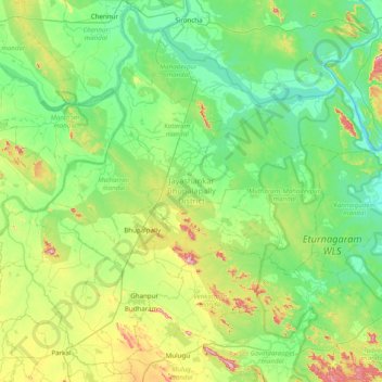
Name: Jayashankar Bhupalapally topographic map, elevation, terrain.
Location: Jayashankar Bhupalapally, Telangana, India (18.15663 79.55910 18.86924 80.34586)
Average elevation: 166 m
Minimum elevation: 73 m
Maximum elevation: 481 m
Make a donation
Other topographic maps
Click on a map to view its topography, its elevation and its terrain.
Secunderabad
Situated in the North of Hyderabad at 17°27′N 78°30′E / 17.45°N 78.5°E / 17.45; 78.5., Secunderabad lies on the northern part of the Deccan Plateau. Secunderabad has an average elevation of 543 metres (1781 ft). Most of the area has a rocky terrain and some areas are hilly.
Average elevation: 544 m
Make a donation
Make a donation
Adilabad
India > Telangana > Adilabad Urban Mandal
Adilabad has an average elevation of 264 metres. The district shares its boundaries with Nirmal districts of Telangana to the south, Komaram Bheem district on the east, with Nanded on the west and Yavatmal and Chandrapur districts of Maharashtra to the north.
Average elevation: 310 m
Make a donation
Make a donation
Make a donation
Make a donation
Make a donation
Make a donation
Sircilla
India > Telangana > Sircilla mandal
The town is located at 18°23′N 78°50′E / 18.38°N 78.83°E / 18.38; 78.83. It has an average elevation of 322 metres (1056 feet). By road, it is located 120 km north of Secunderabad, 40 km west of Karimnagar, 30 km north of Siddipet and 56 km east of Kamareddy. It is 10 km away from the famous…
Average elevation: 338 m
Make a donation
Make a donation
Nalgonda
India > Telangana > Nalgonda mandal
Nalgonda is located at 17°03′00″N 79°16′00″E / 17.050°N 79.2667°E / 17.050; 79.2667. It has an average elevation of 420 metres (1,380 ft).
Average elevation: 219 m
Make a donation
Make a donation
Nirmal
India > Telangana > Nirmal mandal
Nirmal is located at 19°06′N 78°21′E / 19.10°N 78.35°E / 19.10; 78.35. It has an average elevation of 340 metres (1100 feet) on the foot hills of Nirmal range, which is located in the Deccan plateau.Nirmal has chain tanks built around it.
Average elevation: 335 m
Make a donation
Make a donation
Make a donation
Make a donation
Make a donation
Make a donation
Make a donation
Make a donation
Make a donation
Make a donation
Warangal
India > Telangana > Warangal mandal
Warangal is located at 18°00′N 79°35′E / 18.0°N 79.58°E / 18.0; 79.58. It has an average elevation of 266 metres (873 feet). It is settled in the eastern part of Deccan Plateau made up of granite rocks and hill formations which left the region barren making the cultivation dependent on…
Average elevation: 268 m
Kothagudem
India > Telangana > Kothagudem mandal
Kothagudem is located at 17°33′00″N 80°37′05″E / 17.55°N 80.618°E / 17.55; 80.618. It has an average elevation of 89 metres (295 ft) above sea level. The North of Kothagudem borders Chhattisgarh state which is approximately 120 km from the town.
Average elevation: 109 m
Make a donation
Make a donation
Make a donation