
Make a donation
Jogulamba Gadwal topographic map
Click on the map to display elevation.
Make a donation
About this map
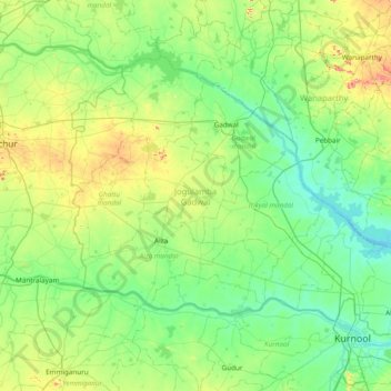
Name: Jogulamba Gadwal topographic map, elevation, terrain.
Location: Jogulamba Gadwal, Telangana, India (15.83635 77.48630 16.36329 78.25322)
Average elevation: 338 m
Minimum elevation: 259 m
Maximum elevation: 617 m
Make a donation
Other topographic maps
Click on a map to view its topography, its elevation and its terrain.
Make a donation
Secunderabad
Situated in the North of Hyderabad at 17°27′N 78°30′E / 17.45°N 78.5°E / 17.45; 78.5., Secunderabad lies on the northern part of the Deccan Plateau. Secunderabad has an average elevation of 543 metres (1781 ft). Most of the area has a rocky terrain and some areas are hilly.
Average elevation: 544 m
Make a donation
Make a donation
Make a donation
Make a donation
Make a donation
Make a donation
Warangal
India > Telangana > Warangal mandal
Warangal is located at 18°00′N 79°35′E / 18.0°N 79.58°E / 18.0; 79.58. It has an average elevation of 266 metres (873 feet). It is settled in the eastern part of Deccan Plateau made up of granite rocks and hill formations which left the region barren making the cultivation dependent on…
Average elevation: 268 m
Kothagudem
India > Telangana > Kothagudem mandal
Kothagudem is located at 17°33′00″N 80°37′05″E / 17.55°N 80.618°E / 17.55; 80.618. It has an average elevation of 89 metres (295 ft) above sea level. The North of Kothagudem borders Chhattisgarh state which is approximately 120 km from the town.
Average elevation: 109 m
Make a donation
Make a donation
Make a donation
Make a donation
Make a donation
Mahbubnagar
India > Telangana > Mahabubnagar_Urban mandal
Mahbub Nagar is located at 16°44′N 77°59′E / 16.73°N 77.98°E / 16.73; 77.98. It has an average elevation of 498 metres (1633 feet). The city of Mahbub Nagar is located at a distance of 98 km from Hyderabad 130 km from Kurnool and 105 km from Raichur.
Average elevation: 509 m
Make a donation
Make a donation
Make a donation
Chandur
India > Telangana > Chandur mandal
Chandur is located at 16°59′N 79°04′E / 16.98°N 79.06°E / 16.98; 79.06. It has an average elevation of 484 metres (1587 feet).
Average elevation: 256 m
Make a donation
Make a donation
Kalkoda
India > Telangana > Marpalle mandal
Kalkoda is located at 17°28′31″N 77°43′34″E / 17.475388°N 77.726030°E / 17.475388; 77.726030. It has an average elevation of 617 metres (2027 ft).
Average elevation: 590 m
Make a donation
Make a donation
Make a donation
Make a donation
Sircilla
India > Telangana > Sircilla mandal
The town is located at 18°23′N 78°50′E / 18.38°N 78.83°E / 18.38; 78.83. It has an average elevation of 322 metres (1056 feet). By road, it is located 120 km north of Secunderabad, 40 km west of Karimnagar, 30 km north of Siddipet and 56 km east of Kamareddy. It is 10 km away from the famous…
Average elevation: 338 m
Make a donation
Make a donation
Make a donation
Make a donation