Geolocate

Aruvikkara Check Dam cum Bridge (DS) topographic map

Interactive map

Click on the map to display elevation.

About this map

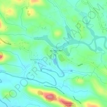
Name: Aruvikkara Check Dam cum Bridge (DS) topographic map, elevation, terrain.

Location: Aruvikkara Check Dam cum Bridge (DS), Nedumangad, Thiruvananthapuram, Kerala, 685541, India (8.57258 77.02032 8.57262 77.02098)

Average elevation: 64 m

Minimum elevation: 30 m

Maximum elevation: 142 m

Other topographic maps

Click on a map to view its topography, its elevation and its terrain.

Kochi

India > Kerala > Kochi

Average elevation: 4 m

Thiruvananthapuram

India > Kerala > Thiruvananthapuram

Thiruvananthapuram is built on seven hills by the seashore and is at 8°30′N 76°54′E / 8.5°N 76.9°E / 8.5; 76.9 on the west coast, near the southern tip of mainland India. The city is on the west coast of India and is bounded by the Laccadive Sea to its west and the Western Ghats to its east.…

Average elevation: 33 m

Idukki

India > Kerala

Though it is the second-largest district in the region in terms of area, it has the lowest population density among the districts of Kerala. There are only two municipalities in the district and the urban population is comparatively much lower than the rural population, due to its mountainous nature. The 2,695…

Average elevation: 607 m

Anakkampoyil

India > Kerala > Thamarassery

Average elevation: 396 m

Western Ghats

India > Kerala > Devikulam

The range starts near south of the Tapti river and runs approximately 1,600 km (990 mi) through the states of Gujarat, Maharashtra, Karnataka, Goa, Kerala and Tamil Nadu ending at Marunthuvazh Malai, Swamithope near the southern tip of India. These hills cover 160,000 km2 (62,000 sq mi) and form the catchment…

Average elevation: 2,225 m

Ellakkal

India > Kerala > Devikulam

Average elevation: 821 m

Rajamudy

India > Kerala > Idukki > Prakash

Average elevation: 820 m

Choondal

India > Kerala > Udumbanchola

Average elevation: 1,414 m

Moonam Kai

India > Kerala > Vadakara

Average elevation: 85 m

Perinthalmanna

India > Kerala

Average elevation: 76 m

Kidangoor

India > Kerala > Meenachil

Average elevation: 29 m

Anjoor

India > Kerala > Kunnamkulam > Kunnamkulam

Average elevation: 8 m

Ramanthali

India > Kerala > Payyannur Taluk

Average elevation: 20 m

Vythiri

India > Kerala

Average elevation: 746 m

Kozhinjampara

India > Kerala > Chittur

Average elevation: 156 m

Bheemanady

India > Kerala > Vellarikkundu

Average elevation: 99 m

Maruthimoodu

India > Kerala > Adoor > Enadimangalam

Average elevation: 83 m

Adhur

India > Kerala > Kasaragod

Average elevation: 123 m

Pettimudi

India > Kerala > Devikulam > Adimali

Average elevation: 810 m

Tanur

India > Kerala > Tirur

Tanur is located at 10°58′N 75°52′E / 10.97°N 75.87°E / 10.97; 75.87. It has an average elevation of 1 m (3.3 ft).

Average elevation: 8 m

Kanathur

India > Kerala > Kasaragod

Average elevation: 106 m

Anakuthi

India > Kerala > Idukki > Kattappana

Average elevation: 990 m

Konni

India > Kerala > Konni

Average elevation: 78 m

Elappara

India > Kerala > Peerumade

Elappara is a town in Idukki district in the southwestern Indian state of Kerala. It is one of the panchayaths in Peerumedu taluk. The area is marked by a cool climate as the region is situated at an elevation of over 1,000 m (3,300 ft) above sea level. Elappara is famous for its vast tea plantations.

Average elevation: 1,049 m

Malampuzha

India > Kerala > Palakkad

Average elevation: 101 m

Vannappuram

India > Kerala > Thodupuzha

Average elevation: 100 m

Thalassery

India > Kerala > Thalassery

Average elevation: 9 m

Valavoor

India > Kerala > Meenachil

Average elevation: 63 m

Cherpunkal

India > Kerala > Meenachil

Average elevation: 28 m

Wayanad

India > Kerala

Wayanad (IPA: [ʋɐjɐnaːɖɨ̆]) is a district in the north-east of Indian state Kerala with administrative headquarters at the municipality of Kalpetta. It is the only plateau in Kerala. The Wayanad Plateau forms a continuation of the Mysore Plateau, the southern portion of Deccan Plateau. It is set high in…

Average elevation: 724 m

Thalayolaparambu

India > Kerala > Vaikom

Average elevation: 10 m

Anthikkad

India > Kerala > Thrissur

Average elevation: 5 m

Nilambur

India > Kerala > Nilambur

The 2,554 m (8,379 ft) m high Mukurthi peak, which is situated in the border of Nilambur Taluk and Ooty Taluk, and is also the fifth-highest peak in South India as well as the third-highest in Kerala after Anamudi (2,696 m [8,845 ft]) and Meesapulimala (2,651 m [8,698 ft]), is the highest point of elevation in…

Average elevation: 33 m

Vallakkunnu

India > Kerala > Chalakkudy

Average elevation: 10 m

Attingal

India > Kerala > Chirayinkeezhu

Average elevation: 25 m

Pareekkanni

India > Kerala > Kothamangalam

Average elevation: 47 m

Kuruvikkoodu

India > Kerala > Kanjirappally

Average elevation: 67 m

Adichanallur

India > Kerala > Kollam

Average elevation: 19 m

Athikkattukulangara

India > Kerala > Mavelikkara

Average elevation: 33 m

Kothamangalam

India > Kerala

Average elevation: 402 m

Alappuzha

India > Kerala

The Vembanad lake, which lies below the sea level, is the longest lake in the Indian peninsula, and the district of Alappuzha lies between this lake and the Arabian Sea. Kuttanad region of the Alappuzha district, which lies below the sea level, is the point of least elevation in the entire India. Kuttanad,…

Average elevation: 21 m

Pulikkanny

India > Kerala > Chalakkudy

Average elevation: 36 m

Periyar Lake

India > Kerala > Peerumade > Thekkady

Average elevation: 961 m

Thaalikad

India > Kerala > Thalassery

Average elevation: 67 m

Thookkupalam

India > Kerala > Udumbanchola

Average elevation: 968 m

Neduvathoor

India > Kerala > Kottarakkara

Average elevation: 66 m

Chembra

India > Kerala > Koyilandi

Average elevation: 46 m

Manatheri

India > Kerala > Thalassery > Kaitheri > Manantheri

Average elevation: 63 m

Kattappana

India > Kerala > Idukki

The average elevation of Kattappana Municipality is 950 m above sea level.

Average elevation: 950 m

Vilangad

India > Kerala > Vadakara

Average elevation: 27 m

Nellarimannam Colony

India > Kerala > Mananthavady > Makkiyad

Average elevation: 847 m

Palolipalam

India > Kerala > Vadakara

Average elevation: 12 m

Palakkad

India > Kerala

Palakkad district (Malayalam: [pɐːlɐkːɐːɖɨ̆] ) is one of the 14 districts in the Indian state of Kerala. It was carved out of the southeastern region of the former Malabar District on 1 January 1957. It is located at the central region of Kerala and is the second largest district in the state after…

Average elevation: 306 m

Enaathu

India > Kerala > Adoor

Average elevation: 30 m

Iritty

India > Kerala > Iritty

Average elevation: 65 m

Mankara

India > Kerala > Palakkad

Average elevation: 65 m

Marayoor

India > Kerala > Devikulam

Ezhuthu Guha rock paintings are sited in the Koodakavu Sandalwood Reserve Forest at Marayur in the Marayur Panchayat at an elevation of 1000 meters above mean sea level. More or less 90 painted motifs can be seen here. However, as the place is the most famous rock art site in Kerala, it attracts a large number…

Average elevation: 1,071 m

Meenangadi

India > Kerala > Sulthanbathery

Average elevation: 760 m

40th Mile

India > Kerala > Peerumade > Peruvanthanam

Average elevation: 373 m

Dharmadom

India > Kerala > Thalassery

Average elevation: 8 m

Thiruthiparambu East

India > Kerala > Chalakkudy > Chalakudy

Average elevation: 10 m

Thookkupalam

India > Kerala > Udumbanchola

Average elevation: 968 m

Adimali

India > Kerala > Devikulam

Adimaly generally has a cool climate throughout the year, typical of the higher altitudes, though not as cold as Munnar. Temperatures rarely exceed 26 degrees and never drop below 10 degrees as it usually stays around 17-24 degrees. December and January are cooler than other months. Adimaly is a place with…

Average elevation: 786 m

Thiruthiparambu

India > Kerala > Talappilly

Average elevation: 36 m

Cumbummettu

India > Kerala > Udumbanchola

Average elevation: 953 m

Angadikadavu

India > Kerala > Iritty

Average elevation: 96 m

St James Hospital

India > Kerala > Chalakkudy > Chalakudy

Average elevation: 14 m

Chellarcovil

India > Kerala > Udumbanchola > Chellarkovil

Average elevation: 1,059 m

West Para

India > Kerala > Udumbanchola > Chottupara

Average elevation: 941 m

Peringode

India > Kerala > Palakkad

Average elevation: 83 m

Thookupalam

India > Kerala > Udumbanchola > Pushpakandam

Average elevation: 910 m

Kayamkulam

India > Kerala > Karthikappally

Average elevation: 8 m

Konni

India > Kerala > Konni

Average elevation: 78 m

Muttil

India > Kerala > Vythiri

Average elevation: 785 m

Iritty

India > Kerala

Average elevation: 345 m

Puracherry

India > Kerala > Payyannur Taluk

Average elevation: 12 m

Kochi

India > Kerala > Kochi

Average elevation: 4 m

Elephant Pond

India > Kerala > Devikulam > Munnar

Average elevation: 477 m

Ernad

India > Kerala

Average elevation: 75 m

Chemmanad

India > Kerala > Kasaragod

Average elevation: 21 m

Thenmala

India > Kerala > Punalur

Average elevation: 212 m

Idinjillam

India > Kerala > Thiruvalla

Average elevation: 5 m

Meesapulimala

India > Kerala > Devikulam

Average elevation: 2,228 m

Chettiarangadi

India > Kerala > Perinthalmanna > Pottipara

Average elevation: 73 m

Kappamkolly

India > Kerala

Average elevation: 836 m

Cherat

India > Kerala > Payyannur Taluk > Edat

Average elevation: 7 m

Tirurangadi

India > Kerala > Tirurangadi

Tirurangadi is located at 11°03′N 75°56′E / 11.05°N 75.93°E / 11.05; 75.93. It has an average elevation of 10 m (33 ft).

Average elevation: 24 m

Mayyanad

India > Kerala > Kollam

Average elevation: 11 m

Malippara

India > Kerala > Kothamangalam

Average elevation: 53 m

Eranholi

India > Kerala > Thalassery > Thalassery

Average elevation: 16 m

Mulakulam

India > Kerala > Vaikom

Average elevation: 15 m

Perinthalmanna

India > Kerala

Average elevation: 76 m

Mangattivayal

India > Kerala > Koyilandi > Ekarool

Average elevation: 49 m

Kanhangad

India > Kerala > Hosdurg > ലക്ഷ്മിനഗരം

Kanhangad lies at 12°18′0″N 75°5.4′0″E in the geographic map of Kasaragod. It is a coastal town which has a varied topography with plain areas in the centre of the city. The landscape is dominated by the characteristic coconut palms accompanying rolling hills and streams flowing into the sea. In the…

Average elevation: 19 m

Charummoodu

India > Kerala > Mavelikkara

Average elevation: 21 m

Peechi

India > Kerala > Thrissur

Average elevation: 86 m

Kattaikonam

India > Kerala > Thiruvananthapuram

Average elevation: 52 m

Athani

India > Kerala > Aluva

Average elevation: 9 m