
Thank you for supporting this site ❤️
Make a donation
Make a donation
Puthenchira topographic map
Click on the map to display elevation.
Thank you for supporting this site ❤️
Make a donation
Make a donation
About this map
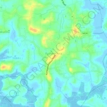
Name: Puthenchira topographic map, elevation, terrain.
Location: Puthenchira, Mukundapuram, Thrissur, Kerala, 680682, India (10.24593 76.21692 10.28593 76.25692)
Average elevation: 8 m
Minimum elevation: -7 m
Maximum elevation: 29 m
Thank you for supporting this site ❤️
Make a donation
Make a donation
Other topographic maps
Click on a map to view its topography, its elevation and its terrain.
Thank you for supporting this site ❤️
Make a donation
Make a donation
Thank you for supporting this site ❤️
Make a donation
Make a donation