
Make a donation
Patan topographic map
Click on the map to display elevation.
Make a donation
About this map
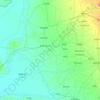
Name: Patan topographic map, elevation, terrain.
Location: Patan, Gujarat, India (23.39203 71.03397 24.15531 72.48249)
Average elevation: 45 m
Minimum elevation: 0 m
Maximum elevation: 452 m
Make a donation
Other topographic maps
Click on a map to view its topography, its elevation and its terrain.
Surat
India > Gujarat > Katargam Taluka > Surat
Surat is a port city situated on the banks of the Tapi river. Damming of the Tapi caused the original port facilities to close; the nearest port is now in the Magadalla and Hazira area of Surat Metropolitan Region.It has famous beach called 'Dumas Beach' located in Hazira. The city is located at 21°10′N…
Average elevation: 11 m
Vadodara
India > Gujarat > Vadodara Rural Taluka
Vadodara is located at 22°18′N 73°11′E / 22.30°N 73.19°E / 22.30; 73.19 in western India at an elevation of 39 metres (128 ft). It is the tenth-largest city in India with an area of 400 square kilometres (150 sq mi) and a population of 3.5 million, according to the 2010–11 census. The city…
Average elevation: 36 m
Make a donation
Make a donation
Make a donation
Make a donation
Palanpur
India > Gujarat > Palanpur Taluka
Palanpur is located at 24°06′N 72°15′E / 24.10°N 72.25°E / 24.10; 72.25. It has an average elevation of 209 metres (685 ft).
Average elevation: 218 m
Make a donation
Amroli
India > Gujarat > Adajan Taluka
The city is located at an average elevation of 12 metres (66 feet).
Average elevation: 15 m
Make a donation
Rajkot
India > Gujarat > Rajkot East Taluka
Rajkot is located at 22°18′N 70°47′E / 22.3°N 70.78°E / 22.3; 70.78. It has an average elevation of 128 metres (420 ft). The city is located on the bank of Aji River and Nyari River which remains dry except the monsoon months of July to September. The city is spread in the area of 170.00 km².
Average elevation: 141 m
Make a donation
Bhavnagar
India > Gujarat > Bhavnagar Taluka
Bhavnagar is a coastal city on the eastern coast of Saurashtra, also known as Kathiawar, located at 21°46′N 72°09′E / 21.77°N 72.15°E / 21.77; 72.15. It has an average elevation of 24 metres or 78.7 feet. It occupies an area of 53.3 square kilometres or 20.6 square miles and is the fifth most…
Average elevation: 23 m
Make a donation
Mahesana
India > Gujarat > Mahesana Taluka
Mehsana has an average elevation of 375 feet (114 m) above sea level. By Ahmedabad-Palanpur Railway line, the town is divided in two: the east and western parts are known as Mehsana-1 and Mehsana-2 respectively.
Average elevation: 92 m
Kheralu
India > Gujarat > Kheralu Taluka
Kheralu is located at 23°53′N 72°37′E / 23.88°N 72.62°E / 23.88; 72.62. It has an average elevation of 149 metres (488 feet).
Average elevation: 172 m
Make a donation
Amroli
India > Gujarat > Adajan Taluka
The city is located at an average elevation of 12 metres (66 feet).
Average elevation: 15 m
Make a donation
Make a donation
Make a donation
Make a donation
Palitana
India > Gujarat > Palitana Taluka
Palitana is located at 21°31′N 71°50′E / 21.52°N 71.83°E / 21.52; 71.83. It has an average elevation of 67 metres (219 feet). The Palitana dam, an irrigation resource, is on the Shetrunji River.
Average elevation: 92 m
Make a donation
Rapar
India > Gujarat > Rapar Taluka
Rapar (earlier known as Rahpar) is located at 23°34′N 70°38′E / 23.57°N 70.63°E / 23.57; 70.63. It has an average elevation of 79 metres (259 feet). Rapar is the main town in the Vagad Region of the Kutch District and the easternmost town of the Kutch District.
Average elevation: 70 m
Make a donation
Bhavnagar
India > Gujarat > Bhavnagar Taluka
Bhavnagar is a coastal city on the eastern coast of Saurashtra, also known as Kathiawar, located at 21°46′N 72°09′E / 21.77°N 72.15°E / 21.77; 72.15. It has an average elevation of 24 metres (78 ft). It occupies an area of 53.3 km2 (20.6 sq mi) and 5th most populated city of Gujarat. The…
Average elevation: 23 m
Palitana
India > Gujarat > Palitana Taluka
Palitana is located at 21°31′N 71°50′E / 21.52°N 71.83°E / 21.52; 71.83. It has an average elevation of 67 metres (219 feet). The Palitana dam, an irrigation resource, is on the Shetrunji River.
Average elevation: 92 m
Make a donation
Make a donation
Make a donation
Gondal
India > Gujarat > Gondal Taluka
Gondal is located at 21°58′N 70°48′E / 21.97°N 70.8°E / 21.97; 70.8. It has an average elevation of 132 metres (433 feet).
Average elevation: 143 m
Dhari
India > Gujarat > Dhari Taluka
Dhari is located at 21°19′36″N 71°01′31″E / 21.3266°N 71.0253°E / 21.3266; 71.0253. It has an average elevation of 216m (708') above sea level. The city is located in Saurashtra region of Gujarat and is situated near the Shetrunji River, which is passes north of Palitana's hills,…
Average elevation: 221 m
Make a donation
Make a donation
Make a donation
Kapadvanj
India > Gujarat > Kapadvanj Taluka
Kapadvanj is located at 23°01′N 73°04′E / 23.02°N 73.07°E / 23.02; 73.07. It has an average elevation of 69 metres (226 feet).
Average elevation: 77 m
Make a donation
Porbandar
India > Gujarat > Porbandar Taluka
Porbandar is located at 21°37′48″N 69°36′0″E / 21.63000°N 69.60000°E / 21.63000; 69.60000. It has an average elevation of 1 metre (3 ft).
Average elevation: 18 m
Viramgam
India > Gujarat > Viramgam Taluka
Viramgam is located at 23°07′N 72°02′E / 23.12°N 72.03°E / 23.12; 72.03. It has an average elevation of 32 metres (105 ft). The old town of Viramgam is surrounded by a rectangular, tower flanked brick and stone wall, about 21 miles round.
Average elevation: 28 m
Make a donation
Make a donation