
Yavatmal topographic map
Interactive map
Click on the map to display elevation.
About this map
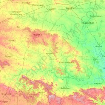
Name: Yavatmal topographic map, elevation, terrain.
Location: Yavatmal, Maharashtra, 445300, India (19.45000 77.65000 20.85000 79.05000)
Average elevation: 308 m
Minimum elevation: 167 m
Maximum elevation: 637 m
Other topographic maps
Click on a map to view its topography, its elevation and its terrain.
Mumbai
India > Maharashtra > Mumbai
Mumbai is on a narrow peninsula on the southwest of Salsette Island, which lies between the Arabian Sea to the west, Thane Creek to the east and Vasai Creek to the north. Mumbai's suburban district occupies most of the island. Navi Mumbai is east of Thane Creek and Thane is north of Vasai Creek. Mumbai…
Average elevation: 18 m
Pune
Pune lies on the western margin of the Deccan plateau, at an altitude of 560 m (1,840 ft) above sea level. It is on the leeward side of the Sahyadri mountain range, which forms a barrier from the Arabian Sea. It is a hilly city, with Vetal Hill rising to 800 m (2,600 ft) above sea level. The Sinhagad fort is…
Average elevation: 616 m
Navi Mumbai
India > Maharashtra > Thane Taluka
Navi Mumbai (Marathi pronunciation: [nəʋiː mumbəiː]), is a planned city situated on the west coast of the Indian subcontinent, located in the Konkan division of Maharashtra state, on the mainland of India. Navi Mumbai is part of the Mumbai Metropolitan Region (MMR). The city is divided into two, North…
Average elevation: 22 m
Gangapur
Gangapur is located on the western side of the Aurangabad-Ahmednagar Highway, 38 km from Aurangabad. It is a taluka place in the historical district of Aurangabad. Gangapur is city of holy temples, ancient Lord Narshimha Temple, Vitthal Mandir, Ek Mukhi Datta Temple, Rameshwar Temple, Gudhicha Maroti and…
Average elevation: 511 m
Ratnagiri
An outstanding feature of the geography of the district is its uneven or hill topography, with about 45% of the district being characterized as 'hilly'. Very narrow riverine plains fringe the coastline.
Average elevation: 301 m
Chandur Railway
Chandur Railway is located at 20.8142° N, 77.9767° E . It has an average elevation of 332 metres (1089 feet).
Average elevation: 319 m
Buldhana District
Lonarkar Top (about 923 meters) is highest altitude in Buldhana District placed in Ambabarwa Wildlife Sanctuary.
Average elevation: 425 m
Daryapur
Daryapur is located at 20.9300° N, 77.3300° E and coordinates at an average elevation of 288m .https://www.latlong.net/place/daryapur-maharashtra-india-11715.html
Average elevation: 295 m
Murtijapur
Murtijapur is located at an average elevation of 308 metres (1210 feet). It is an important railway junction station in Akola district. It is under the Bhusawal-Badnera Section of Bhusawal Division of Central Railway.
Average elevation: 308 m
Nanded District
Nanded is bounded on the north by Yavatmal district of the Vidarbha region, with Latur on south-west, Parbhani and Hingoli districts on the west. On the eastern side lies Adilabad, Nirmal, Nizamabad and Kamareddy districts of Telangana state, and on the south lies Bidar of Karnataka state. The area presents…
Average elevation: 432 m
Jalna District
The district occupies an area of 7,687 square kilometres (2,968 sq mi). The range of geographical latitudes and longitudes of the district is from 19.01' N to 21.03'N and from 75.04'E to 76.04'E, with gently to moderately sloping topography. The Northern part of the district is occupied by the Ajanta and…
Average elevation: 542 m
Khuldabad
Khuldabad is located at 20°03′N 75°11′E / 20.05°N 75.18°E / 20.05; 75.18. It enjoys a pleasant climate, moderated by its altitude (2,732 feet / 832.7 metres). The town rises about 500 feet (152.4 metres) above the surrounding plains. The world famous Ellora caves are about 4 miles from…
Average elevation: 661 m
Latur District
Latur district is in the Marathwada region in Maharashtra in India, located between 17°52' North to 18°50' North and 76°18' East to 79°12' East in the Deccan plateau. It has an average elevation of 631 metres (2,070 ft) above mean sea level. The entire district of Latur is on the Balaghat plateau, 540 to…
Average elevation: 590 m