
Panna topographic map
Click on the map to display elevation.
About this map
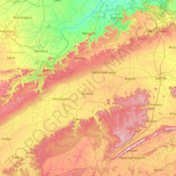
Name: Panna topographic map, elevation, terrain.
Location: Panna, Panna District, Madhya Pradesh, 488058, India (23.80000 79.55000 25.20000 80.95000)
Average elevation: 336 m
Minimum elevation: 110 m
Maximum elevation: 668 m
Other topographic maps
Click on a map to view its topography, its elevation and its terrain.
Betul
The mean elevation above the sea is about 2000 ft. The country is essentially a highland tract, divided naturally into three distinct portions, differing in their superficial aspects, the character of their soil and their geological formation. The northern part of the district forms an irregular plain of the…
Average elevation: 533 m
Chhindwara
The altitude of the district varies from 1,550 ft (470 m) to 3,820 ft (1,160 m) above sea level with an average elevation of 2215 feet (675 m).
Average elevation: 619 m
Rajgarh
The Newaj is left bank tributary of the river Parwan which is a right bank principal tributary of the Kalisindh. The Newaj River rises at an elevation of 634 m in the Astha tehsil of the Sehore district in Madhya Pradesh and traverses a total length of 220 km, out of which 205 km is in Madhya Pradesh. The…
Average elevation: 429 m
Ashoknagar
Ashoknagar is situated at the average elevation of 507 metres(1640 ft) above sea level. It is in the plateau region. It has an agricultural topography. The plateau is an extension of the Deccan Traps, formed between 60 and 68 million years ago at the end of the Cretaceous period. In this region, the main…
Average elevation: 447 m
Dewas
Due to its high elevation and inland location, even during the hottest months of the year, the nights are relatively cool, which is known as Shab-e-Malwa. Three distinct seasons are observed: summer, monsoon and winter. Dewas gets most of its rainfall during July–September due to the southwest monsoon.
Average elevation: 445 m
Guna
Guna is located at 24.65°N 77.32°E.[1] It has an average elevation of 474 metres (1555 ft).
Average elevation: 434 m
Narmadapuram
Pachmarhi is known for its natural environment, and lies at an altitude of 3,555 feet. It is surrounded by the Satpura hills. Satpura National Park and Madai Tiger Reserve are wildlife.
Average elevation: 458 m
Narsinghpur
The district sits in the basin of the Narmada River. The Vindhya Range skirts the northern end of the district. The Satpura Range forms the district's southern boundary. It is located between 22°55' and 23°15' north latitude, and 78°38' and 79°38' east longitudes. It has an average elevation of 359.8 m…
Average elevation: 477 m