
Buncombe County topographic map
Interactive map
Click on the map to display elevation.
About this map
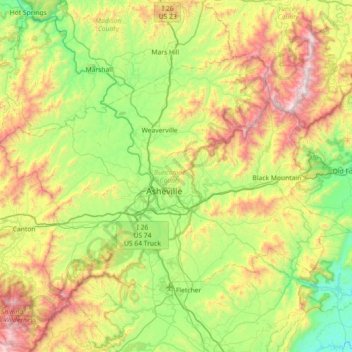
Name: Buncombe County topographic map, elevation, terrain.
Location: Buncombe County, North Carolina, United States (35.41646 -82.88811 35.82412 -82.16905)
Average elevation: 839 m
Minimum elevation: 258 m
Maximum elevation: 2,005 m
Other topographic maps
Click on a map to view its topography, its elevation and its terrain.
Siler City Water Supply Lake Number One Dam
United States > North Carolina > Chatham County
Average elevation: 187 m
Appalachian Mountains
United States > North Carolina > Yancey County
The Appalachian Mountains, often called the Appalachians, are a system of mountains in eastern North America. The Appalachians first formed roughly 480 million years ago during the Ordovician Period. They once reached elevations similar to those of the Alps and the Rocky Mountains before experiencing natural…
Average elevation: 1,463 m