
Nowgong topographic map
Interactive map
Click on the map to display elevation.
About this map
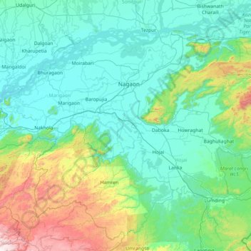
Name: Nowgong topographic map, elevation, terrain.
Location: Nowgong, Nagaon, Assam, India (25.43333 91.96667 26.83333 93.36667)
Average elevation: 311 m
Minimum elevation: 45 m
Maximum elevation: 1,882 m
Other topographic maps
Click on a map to view its topography, its elevation and its terrain.
Dhubri
Dhubri District is bounded both by interstate and international borders: West Bengal and Bangladesh in the west; Goalpara and Bogaigoan district of Assam and Garo Hills district of Meghalaya in the east; Kokrajhar district in the north; and Bangladesh and state of Meghalaya in the south. The district is…
Average elevation: 52 m