
Make a donation
Haflong topographic map
Click on the map to display elevation.
Make a donation
About this map
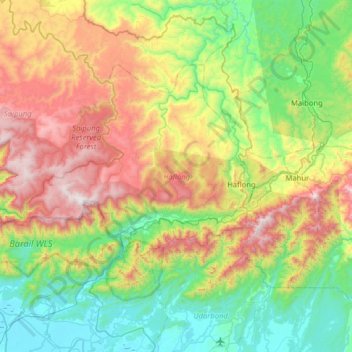
Name: Haflong topographic map, elevation, terrain.
Location: Haflong, Dima Hasao, Assam, India (25.00055 92.52051 25.36443 93.15428)
Average elevation: 576 m
Minimum elevation: 13 m
Maximum elevation: 1,698 m
Make a donation
Other topographic maps
Click on a map to view its topography, its elevation and its terrain.
Guwahati
Professor Abani Kumar Bhagawati of Gauhati University stated that since before there were sufficient wetlands to absorb rainwater and channels to carry excess water to the Brahmaputra, the city did not experience floods. However, human interference has disrupted the natural topography, leading to the current…
Average elevation: 113 m
Make a donation
Make a donation
Udalguri
India > Assam > Udalguri tehsil
Odalguri is located at 26°44′43″N 92°05′46″E / 26.7452°N 92.0962°E / 26.7452; 92.0962. It has an average elevation of 180 metres (590 ft).
Average elevation: 109 m
Make a donation
Make a donation
Make a donation
Make a donation
Barpeta
It is located at 26°19′N 91°00′E / 26.32°N 91.0°E / 26.32; 91.0. It has an average elevation of 35 metres (114 feet). It is 40 km away from Manas National Park. Three rivers - Chaulkhowa, Mora Nodi (Dead River) and Nakhanda, both of which are tributaries to Brahmaputra run through the town.
Average elevation: 40 m
Make a donation
Make a donation
Make a donation
Make a donation
Make a donation
Sonari
Sonari is located at 27°04′N 95°02′E / 27.07°N 95.03°E / 27.07; 95.03. It has an average elevation of 97 metres (318 feet). It is a major town on the nearly 500-year-old "Dhodar Ali" built by the Ahom Kings. Dhodar ali was forcefully commissioned by Ahom king Gadadhar Singha using the…
Average elevation: 106 m
Make a donation
Make a donation
Make a donation
Lumding
Hills of Lumding put the town a notable altitude above the sea level, but summer temperatures can reach up to 40 °C and the winters can be as chilling as 4-5 °C with fog and mist intervening in the early hours of the day. Monsoon is a notable season here, with rainfall around 60–125mm at an average. But…
Average elevation: 159 m
Make a donation
Make a donation
Jorhat
India > Assam > Jorhat East
Jorhat is located at 26°45′N 94°13′E / 26.75°N 94.22°E / 26.75; 94.22. It has an average elevation of 116 metres (381 feet).
Average elevation: 93 m
Guwahati
Professor Abani Kumar Bhagawati of Gauhati University stated that since before there were sufficient wetlands to absorb rainwater and channels to carry excess water to the Brahmaputra, the city did not experience floods. However, human interference has disrupted the natural topography, leading to the current…
Average elevation: 113 m
Make a donation
Make a donation
Make a donation
Guwahati
Professor Abani Kumar Bhagawati of Gauhati University stated that since before there were sufficient wetlands to absorb rainwater and channels to carry excess water to the Brahmaputra, the city did not experience floods. However, human interference has disrupted the natural topography, leading to the current…
Average elevation: 113 m
Make a donation