
Nabarangapur topographic map
Interactive map
Click on the map to display elevation.
About this map
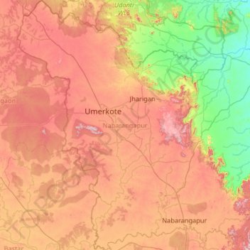
Name: Nabarangapur topographic map, elevation, terrain.
Location: Nabarangapur, Odisha, India (19.11360 81.84523 20.10559 82.85657)
Average elevation: 530 m
Minimum elevation: 215 m
Maximum elevation: 950 m
Nabarangpur district, also known as Nabarangapur district and Nawarangpur district, is a district of Odisha, India. The city of Nabarangpur is the district capital. Most of its population is tribal and the land is heavily forested. It borders Kalahandi and Koraput districts. Nabarangpur district is situated at 19.14′ latitude and 82.32′ longitude at an average elevation of 572 metres (1,877 ft).
Other topographic maps
Click on a map to view its topography, its elevation and its terrain.
Cuttack
India > Odisha > Cuttack (M.Corp.) P.S
Cuttack, Cuttack (M.Corp.) P.S, Cuttack, Odisha, 753001, India
Average elevation: 34 m
Ward 43
India > Odisha > Bhubaneswar (M.Corp.) > Bhubaneswar Municipal Corporation
Ward 43, South East Zone, Bhubaneswar Municipal Corporation, Bhubaneswar (M.Corp.), Khordha District, Odisha, India
Average elevation: 28 m
Barabati
India > Odisha > Dharmasala
Barabati, Dharmasala, Jajpur District, Odisha, 755008, India
Average elevation: 17 m
Subarnapur
Subarnapur, Sonapur, Subarnapur District, Odisha, 767017, India
Average elevation: 112 m
Rushikulya
India > Odisha > Purusottampur
Rushikulya, Purusottampur, Ganjam District, Odisha, India
Average elevation: 32 m
Vamsadhara
India > Odisha > Gudari > Gudari
Vamsadhara, Gudari, Rayagada District, Odisha, 765026, India
Average elevation: 304 m
Brahmapur (M.Corp.)
Brahmapur (M.Corp.), Ganjam District, Odisha, India
Average elevation: 22 m
Ward 44
India > Odisha > Bhubaneswar (M.Corp.) > Bhubaneswar Municipal Corporation
Ward 44, South East Zone, Bhubaneswar Municipal Corporation, Bhubaneswar (M.Corp.), Khordha District, Odisha, India
Average elevation: 21 m
Kusumi
India > Odisha > Mahulpalli
Kusumi, Mahulpalli, Sambalpur District, Odisha, India
Average elevation: 270 m
Boudh
India > Odisha > Baudh Sadar
Boudh, Baudh Sadar, Boudh District, Odisha, 762014, India
Average elevation: 93 m
Kendujhargarh
India > Odisha > Kendujhar Town
Kendujhargarh, Kendujhar Town, Kendujhar District, Odisha, 758001, India
Average elevation: 481 m
Paradeep Lock
Paradeep Lock, Jagatsinghapur District, Odisha, India
Average elevation: 3 m
Brahmani River
Brahmani River, Rajnagar, Kendrapara District, Odisha, India
Average elevation: 3 m
Biramitrapur
India > Odisha > Biramitrapur
Biramitrapur, Sundargarh District, Odisha, 770033, India
Average elevation: 285 m
Narayanpatana
Narayanpatana, Koraput District, Odisha, 764014, India
Average elevation: 677 m
KAIPADAR
India > Odisha > Khordha Sadar
KAIPADAR, Khordha Sadar, Khordha District, Odisha, 752056, India
Average elevation: 62 m