
Sian Ka'an topographic map
Interactive map
Click on the map to display elevation.
About this map
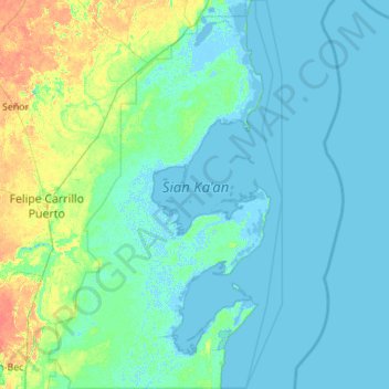
Name: Sian Ka'an topographic map, elevation, terrain.
Location: Sian Ka'an, Mexico (19.08670 -88.04041 20.12783 -87.37666)
Average elevation: 4 m
Minimum elevation: -5 m
Maximum elevation: 25 m
Other topographic maps
Click on a map to view its topography, its elevation and its terrain.
Paseo al Monte (Camino a la Boquilla)
Mexico > Zacatecas > Moyahua de Estrada > Moyahua de Estrada
Average elevation: 1,224 m
Texcoco de Mora
Mexico > State of Mexico > Texcoco
Tescoco lies about 25 km east of the centre of Mexico City. Major elevations in the municipality include the Tlaloc Mountain (4,500 meters) the Tetzcutzinco, Moyotepec and Tecuachacho. Most elevations are named after the major community to be found on them. There are also a number of small canyons. Part of the…
Average elevation: 2,262 m
Chihuahua
Mexico > Chihuahua > Municipio de Chihuahua
Chihuahua lies on the western side of the Chihuahuan Desert ecoregion and as such has a semiarid climate (Köppen climate classification BSh). However, it is not as hot as most of the lower elevated portions of the desert to the east owing to an altitude of almost 1,500 metres (4,900 feet) above sea level.
Average elevation: 1,555 m
Hecelchakán
Mexico > Campeche > Hecelchakán
It is at an altitude of 10 m above sea level.
Average elevation: 34 m
Ciudad Victoria
Mexico > Tamaulipas > Victoria
Ciudad Victoria has a climate on the border of humid subtropical (Köppen Cfa/Cwa) and hot semi-arid (BSh). Its weather is characterised by short warm winters and long hot to sweltering summers. Temperatures rarely drop below 0 °C (32 °F) — the lowest recorded temperature was −6 °C (21.2 °F) and the…
Average elevation: 518 m
Mazatlán
Mexico > Sinaloa > Mazatlán > Mazatlán
At the edge of Mazatlán and Concordia runs the Sierra del Metate and Panuco. In this county, the Sierra Madre Occidental is diverted to penetrate Durango, leaving before some detachments, such as the Sierra de San Juan and the Friars, and constitutes, in of its topography, the following hilly areas.
Average elevation: 25 m
Aguascalientes
Mexico > Aguascalientes > Municipio de Aguascalientes
The Aguascalientes Bicentenary Velodrome, designed by Peter Junek, hosted the 2010 Pan American Track Championships. At an elevation of 1887m, the Velodrome is a frequent location for attempts at breaking the Cycling Hour Record.
Average elevation: 1,956 m
Villahermosa
Mexico > Tabasco > Centro > Villahermosa
Villahermosa is located in the southeast of Mexico between the rivers Grijalva and Carrizal. The average elevation of the city is 10 meters above sea level. The city also has several lagoons, the largest and most important of them being La Laguna de las Ilusiones (Illusions Lagoon).
Average elevation: 9 m
Piedras Negras
Mexico > Coahuila > Municipio de Piedras Negras > Piedras Negras
Average elevation: 256 m